IMAGES TAKEN NEAR TO
Iford Lane, BOURNEMOUTH, BH6 5RD
Introduction
This page details the photographs taken nearby to Iford Lane, BH6 5RD by members of the Geograph project.
The Geograph project started in 2005 with the aim of publishing, organising and preserving representative images for every square kilometre of Great Britain, Ireland and the Isle of Man.

There are currently over 7.5m images from over14,400 individuals and you can help contribute to the project by visiting https://www.geograph.org.uk
Image Map (Loading...)


Getting Data...Please wait
Leaflet Map data © OpenStreetMap
Images are licensed for reuse under creativecommons.org/licenses/by-sa/2.0
Notes
- Clicking on the map will re-center to the selected point.
- The higher the marker number, the further away the image location is from the centre of the postcode.
Image Listing (77 Images Found)
Images are licensed for reuse under creativecommons.org/licenses/by-sa/2.0
Image
Details
Distance
3
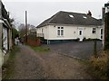
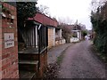
Iford: the only even numbered house in Water Lane
Water Lane is a public right of way, a byway open to all traffic (or B.O.A.T.) number I05, leading from Iford Lane to Old Bridge Road, which latter is, I believe, the historic course of Iford Lane before it was rerouted for motorised traffic.
Here, we look down it as it heads for Old Bridge Road, with the single even-numbered house - number 6 - on the right. The left-hand side has odd numbers 3 to 11.
See Image for the next photo on the lane ahead, and Image for the next view behind us - each with links to further photos.
Image: © Chris Downer
Taken: 8 Jan 2017
0.03 miles
4
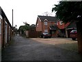
Iford: a view up Water Lane
Water Lane is a public right of way, a byway open to all traffic (or B.O.A.T.) number I05, leading from Iford Lane to Old Bridge Road, which latter is, I believe, the historic course of Iford Lane before it was rerouted for motorised traffic.
Here, we look up the lane with Old Bridge Road and, indeed, the old bridge only a few yards behind us.
See Image for the next photo on the lane behind us, and Image for the next view ahead, with links to further photos.
Image: © Chris Downer
Taken: 8 Jan 2017
0.03 miles
5
Iford: passing 3 Water Lane
Water Lane is a public right of way, a byway open to all traffic (or B.O.A.T.) number I05, leading from Iford Lane to Old Bridge Road, which latter is, I believe, the historic course of Iford Lane before it was rerouted for motorised traffic.
Here, we look down it as it heads for Old Bridge Road - the parked cars visible in the distance are right alongside the old bridge.
See Image for the next photo on the lane ahead, and Image for the next view behind us - each with links to further photos.
Image: © Chris Downer
Taken: 8 Jan 2017
0.03 miles
6
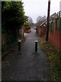
Iford: bollards on Water Lane
Water Lane is a public right of way, a byway open to all traffic (or B.O.A.T.) number I05, leading from Iford Lane to Old Bridge Road, which latter is, I believe, the historic course of Iford Lane before it was rerouted for motorised traffic.
Here, we look down it as it heads for Old Bridge Road - the parked cars visible in the distance are right alongside the old bridge. The bollards remind us that the definition 'byway open to all traffic' is meant in a somewhat theoretical sense - I think they were put in about 15 years ago as it could be used as a short-cut when there were queues at Iford roundabout.
See Image for the next photo on the lane ahead, and Image for the next view behind us - each with links to further photos.
Image: © Chris Downer
Taken: 8 Jan 2017
0.03 miles
7
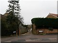
Iford: Water Lane from Iford Lane
Water Lane is a public right of way, a byway open to all traffic (or B.O.A.T.) number I05, leading from Iford Lane to Old Bridge Road, which latter is, I believe, the historic course of Iford Lane before it was rerouted for motorised traffic.
Here, we see it from across Iford Lane as it heads down to the Stour at Old Bridge Road.
See Image for the next photo on the route, with links to further photos.
Image: © Chris Downer
Taken: 8 Jan 2017
0.03 miles
8
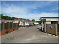
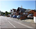
Iford Bridge Caravan Park, near Bournemouth
The entrance to a caravan park at Iford, on the bank of the River Stour near Bournemouth.
Image: © Malc McDonald
Taken: 21 Jun 2022
0.03 miles
9
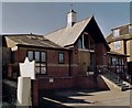
Iford Baptist Church
On Old Bridge Road. http://www.ifordbaptistchurch.co.uk/
Image: © Mike Faherty
Taken: 23 Aug 2012
0.03 miles
10
Iford: Water Lane from Old Bridge Road
Water Lane is a public right of way, a byway open to all traffic (or B.O.A.T.) number I05, leading from Iford Lane to Old Bridge Road, which latter is, I believe, the historic course of Iford Lane before it was rerouted for motorised traffic.
Here, we look up it from Old Bridge Road - with the River Stour and, indeed, the old bridge just behind us.
See Image for the view towards us from a little way up Water Lane - with links to further photos along the lane.
Image: © Chris Downer
Taken: 8 Jan 2017
0.04 miles