IMAGES TAKEN NEAR TO
Iford Lane, BOURNEMOUTH, BH6 5RA
Introduction
This page details the photographs taken nearby to Iford Lane, BH6 5RA by members of the Geograph project.
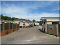
The Geograph project started in 2005 with the aim of publishing, organising and preserving representative images for every square kilometre of Great Britain, Ireland and the Isle of Man.

There are currently over 7.5m images from over14,400 individuals and you can help contribute to the project by visiting https://www.geograph.org.uk
Image Map
Images are licensed for reuse under creativecommons.org/licenses/by-sa/2.0
Notes
- Clicking on the map will re-center to the selected point.
- The higher the marker number, the further away the image location is from the centre of the postcode.
Image Listing (75 Images Found)
Images are licensed for reuse under creativecommons.org/licenses/by-sa/2.0
Image
Details
Distance
1
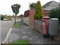
Iford: postbox № BH6 170, Ashford Road
An Elizabeth II-reign postbox at the northern end of Ashford Road. Alongside is a large drop-box, a depository for the postman doing morning deliveries to store part of his round.
Image: © Chris Downer
Taken: 25 Oct 2008
0.02 miles
2
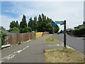
Stour Valley Way, Iford, near Bournemouth
This shared pavement alongside Iford Lane firms part of the Stour Valley Way.
Image: © Malc McDonald
Taken: 21 Jun 2022
0.03 miles
3
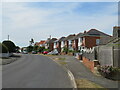
Iford Lane, Iford, near Bournemouth
Iford Lane in Iford, on the north-eastern fringes of Bournemouth.
Image: © Malc McDonald
Taken: 21 Jun 2022
0.03 miles
4
Iford Bridge Caravan Park, near Bournemouth
The entrance to a caravan park at Iford, on the bank of the River Stour near Bournemouth.
Image: © Malc McDonald
Taken: 21 Jun 2022
0.08 miles
6
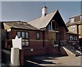
Iford Baptist Church
On Old Bridge Road. http://www.ifordbaptistchurch.co.uk/
Image: © Mike Faherty
Taken: 23 Aug 2012
0.08 miles
7
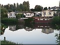
Iford: Iford Bridge Mobile Home Park
These mobile homes have a pleasant appearance reflected in the Stour, although their residents occasionally have cause to see this in slightly less welcoming light when the Stour floods.
Image: © Chris Downer
Taken: 30 Jul 2007
0.09 miles
8

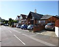
Riverside buildings seen from Iford Bridge
The tall house in the centre was formerly a tea shop. The building to the left is Iford Baptist Church.
Image: © David Martin
Taken: 24 Jan 2022
0.09 miles
9
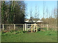
Gate On Iford Meadows, Near Bournemouth
This fence and strong gate were erected to allow cattle to graze on the Iford Meadows Local Nature Reserve.
Image: © Lorraine and Keith Bowdler
Taken: 11 Jan 2012
0.10 miles