IMAGES TAKEN NEAR TO
Iford Lane, BOURNEMOUTH, BH6 5NG
Introduction
This page details the photographs taken nearby to Iford Lane, BH6 5NG by members of the Geograph project.
The Geograph project started in 2005 with the aim of publishing, organising and preserving representative images for every square kilometre of Great Britain, Ireland and the Isle of Man.

There are currently over 7.5m images from over14,400 individuals and you can help contribute to the project by visiting https://www.geograph.org.uk
Image Map (Loading...)


Getting Data...Please wait
Leaflet Map data © OpenStreetMap
Images are licensed for reuse under creativecommons.org/licenses/by-sa/2.0
Notes
- Clicking on the map will re-center to the selected point.
- The higher the marker number, the further away the image location is from the centre of the postcode.
Image Listing (121 Images Found)
Images are licensed for reuse under creativecommons.org/licenses/by-sa/2.0
Image
Details
Distance
1
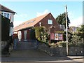
Tuckton: Tuckton Christian Fellowship
This church, between 304 and 308 Iford Lane, is listed as Tuckton Evangelical Free Church in the 1975 Kelly's Directory of Bournemouth.
Image: © Chris Downer
Taken: 9 Mar 2008
0.06 miles
2
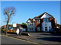
Kings Castle Montessori School
This large house on Saxonbury Rd has been converted to a Montessori school and baby nursery.
Image: © Nigel Mykura
Taken: 15 Nov 2011
0.07 miles
4
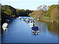
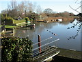
River Stour above Tuckton Bridge
The river is navigable for some way up for small launches.
Image: © Robin Webster
Taken: 6 Nov 2016
0.09 miles
5
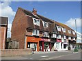
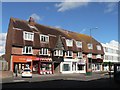
Row of Shops in Tuckton Road
Tuckton Road is Tuckton's High Street. This row of shops is in a building constructed in the first half of the 20th century.
Image: © mike smith
Taken: 13 Aug 2007
0.09 miles
6
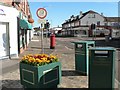
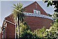
Tuckton: post office
Tuckton post office is at 165 Tuckton Road. The 13-ton weight limit indicated by the sign refers to Tuckton Bridge, which is left at the roundabout a little further on.
Image: © Chris Downer
Taken: 9 Mar 2008
0.11 miles
7
Iford, landing stages
Private landing stages on a bend of the River Stour. Stage for Image is the furthermost left. Taken from river footpath.
Image: © Mike Faherty
Taken: 14 Jan 2009
0.11 miles
8
Tuckton: footpath I17 from Iford Lane
This driveway provides access to the rear of shops (and flats above) in Tuckton Road, and also forms public footpath I17 to Riverside Lane. The direction sign on the left has been turned to point towards us rather than along the route.
See Image for the next view along the driveway, with links to further photos along the route.
Image: © Chris Downer
Taken: 24 Sep 2016
0.12 miles
9
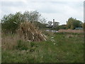
Christchurch, pampas grass
Looking distinctly out of place on open land next to the River Stour; in the distance, on the other bank, Image
Image: © Mike Faherty
Taken: 5 May 2010
0.12 miles
10
Tuckton: 127-133 Tuckton Road
An unusual looking parade of shops in Tuckton Road. Thresher's off licence has occupied no.129 for at least 35 years.
Image: © Chris Downer
Taken: 9 Mar 2008
0.12 miles