IMAGES TAKEN NEAR TO
Shelton Road, BOURNEMOUTH, BH6 5EZ
Introduction
This page details the photographs taken nearby to Shelton Road, BH6 5EZ by members of the Geograph project.
The Geograph project started in 2005 with the aim of publishing, organising and preserving representative images for every square kilometre of Great Britain, Ireland and the Isle of Man.

There are currently over 7.5m images from over14,400 individuals and you can help contribute to the project by visiting https://www.geograph.org.uk
Image Map (Loading...)


Getting Data...Please wait
Leaflet Map data © OpenStreetMap
Images are licensed for reuse under creativecommons.org/licenses/by-sa/2.0
Notes
- Clicking on the map will re-center to the selected point.
- The higher the marker number, the further away the image location is from the centre of the postcode.
Image Listing (84 Images Found)
Images are licensed for reuse under creativecommons.org/licenses/by-sa/2.0
Image
Details
Distance
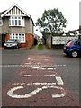
1
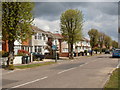
Southbourne, Castleman Avenue
1920s housing on the western side of the Beaufort Estate.
Image: © Mike Faherty
Taken: 3 May 2010
0.05 miles
2
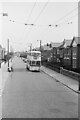
Trolleybus on Beaufort Road ? 1969
On service 23 from Tuckton Bridge via Cranleigh Road, taken on the last day of normal trolleybus operation in Bournemouth.
This is one of a series of views featuring buses in the 60s, 70s, and 80s. http://www.geograph.org.uk/search.php?i=137652761
Image: © Alan Murray-Rust
Taken: 19 Apr 1969
0.12 miles
3
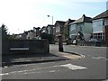
West Southbourne: postbox № BH6 203, Beaufort Road
A George V-reign postbox on the corner of Beaufort and Burleigh Roads.
Image: © Chris Downer
Taken: 20 Sep 2008
0.12 miles
4
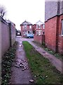
West Southbourne: makeshift surface repair on footpath H09
This is one of seven public footpaths running parallel with and either side of Kimberley Road, serving as rear driveway access to the properties on that road. Complementing the criss-cross arrangements of roads in West Southbourne, they are arranged in the following order:
(northeast side of Kimberley Road)
Castlemain Avenue - footpath H09 - Beaufort Road - footpath H10 - Stamford Road - footpath H13 - Arnewood Road - footpath H14 - Irving Road
(southwest side of Kimberley Road)
Beaufort Road - footpath H11 - Stamford Road - footpath H12 - Arnewood Road - footpath H15 [called Irving Lane] - Irving Road
Here, we look towards Castlemain Avenue on footpath H09, across a part of the surface where a pothole has been levelled with some broken-up slates or chimneypots.
See Image for the view towards us from across the road, and Image for the next view on the path ahead, with links to further photos along the route.
Image: © Chris Downer
Taken: 8 Jan 2017
0.14 miles
5
West Southbourne: across ?Slow? markings and along footpath H09
This is one of seven public footpaths running parallel with and either side of Kimberley Road, serving as rear driveway access to the properties on that road. Complementing the criss-cross arrangements of roads in West Southbourne, they are arranged in the following order:
(northeast side of Kimberley Road)
Castlemain Avenue - footpath H09 - Beaufort Road - footpath H10 - Stamford Road - footpath H13 - Arnewood Road - footpath H14 - Irving Road
(southwest side of Kimberley Road)
Beaufort Road - footpath H11 - Stamford Road - footpath H12 - Arnewood Road - footpath H15 [called Irving Lane] - Irving Road
Here, we look across Castlemain Avenue and along the start of footpath H09 towards Beaufort Road.
See Image for the next view on the path ahead, with links to further photos along the route.
Image: © Chris Downer
Taken: 8 Jan 2017
0.14 miles
6
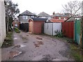
West Southbourne: offset garages on footpath H09
This is one of seven public footpaths running parallel with and either side of Kimberley Road, serving as rear driveway access to the properties on that road. Complementing the criss-cross arrangements of roads in West Southbourne, they are arranged in the following order:
(northeast side of Kimberley Road)
Castlemain Avenue - footpath H09 - Beaufort Road - footpath H10 - Stamford Road - footpath H13 - Arnewood Road - footpath H14 - Irving Road
(southwest side of Kimberley Road)
Beaufort Road - footpath H11 - Stamford Road - footpath H12 - Arnewood Road - footpath H15 [called Irving Lane] - Irving Road
Here, we look along footpath H09 in the direction of Castlemain Avenue, where three garages are set back at slightly different intervals, no doubt easing vehicular access compared to if they were level with each other.
See Image for the view towards us from across the road, and Image for the next view on the path ahead - each with links to further photos along the route.
Image: © Chris Downer
Taken: 8 Jan 2017
0.15 miles
7
West Southbourne: footpath H09 approaches Beaufort Road
This is one of seven public footpaths running parallel with and either side of Kimberley Road, serving as rear driveway access to the properties on that road. Complementing the criss-cross arrangements of roads in West Southbourne, they are arranged in the following order:
(northeast side of Kimberley Road)
Castlemain Avenue - footpath H09 - Beaufort Road - footpath H10 - Stamford Road - footpath H13 - Arnewood Road - footpath H14 - Irving Road
(southwest side of Kimberley Road)
Beaufort Road - footpath H11 - Stamford Road - footpath H12 - Arnewood Road - footpath H15 [called Irving Lane] - Irving Road
Here, we look along footpath H09 in the direction of Beaufort Road, where the continuing route, footpath H10, continues across the road.
See Image for the next view on footpath H10 ahead, and Image for the next view on path H09 behind us - each with links to further photos along the route.
Image: © Chris Downer
Taken: 8 Jan 2017
0.16 miles
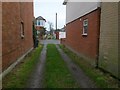
8
West Southbourne: footpath H06 from Kimberley Road
This short public footpath doubles up as a rear access driveway to houses in Kimberley Road (here) and Paisley Road (the next parallel road ahead) - a further driveway, footpath H07, turns off to the right midway along, to run along the backs of both rows of houses.
See Image for the next view along the path, with links to further photos on both mentioned routes.
Image: © Chris Downer
Taken: 8 Jan 2017
0.16 miles
9
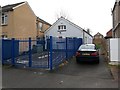
West Southbourne: footpath H08 from Kimberley Road
Looking along this short public footpath which runs alongside a pre-school in Kimberley Road. It leads to a further footpath, H07, which is essentially a rear access driveway for houses in Kimberley Road and Paisley Road, the next parallel street.
See Image for the next photo on the path, with links to further photos along the mentioned routes.
Image: © Chris Downer
Taken: 8 Jan 2017
0.16 miles
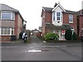
10
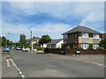
Stamford Road, Southbourne
Stamford Road is a residential road in Southbourne, in the eastern suburbs of Bournemouth. The roads in this neighbourhood are laid out in a grid pattern, with straight streets intersecting at right angles.
Image: © Malc McDonald
Taken: 21 Jun 2022
0.17 miles