
IMAGES TAKEN NEAR TO
Castlemain Avenue, BOURNEMOUTH, BH6 5EL
Introduction
This page details the photographs taken nearby to Castlemain Avenue, BH6 5EL by members of the Geograph project.
The Geograph project started in 2005 with the aim of publishing, organising and preserving representative images for every square kilometre of Great Britain, Ireland and the Isle of Man.

There are currently over 7.5m images from over14,400 individuals and you can help contribute to the project by visiting https://www.geograph.org.uk
Image Map
Images are licensed for reuse under creativecommons.org/licenses/by-sa/2.0
Notes
- Clicking on the map will re-center to the selected point.
- The higher the marker number, the further away the image location is from the centre of the postcode.
Image Listing (86 Images Found)
Images are licensed for reuse under creativecommons.org/licenses/by-sa/2.0
Image
Details
Distance
1
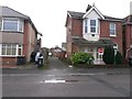
West Southbourne: footpath H06 from Kimberley Road
This short public footpath doubles up as a rear access driveway to houses in Kimberley Road (here) and Paisley Road (the next parallel road ahead) - a further driveway, footpath H07, turns off to the right midway along, to run along the backs of both rows of houses.
See Image for the next view along the path, with links to further photos on both mentioned routes.
Image: © Chris Downer
Taken: 8 Jan 2017
0.05 miles
2
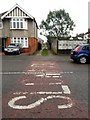
West Southbourne: across ?Slow? markings and along footpath H09
This is one of seven public footpaths running parallel with and either side of Kimberley Road, serving as rear driveway access to the properties on that road. Complementing the criss-cross arrangements of roads in West Southbourne, they are arranged in the following order:
(northeast side of Kimberley Road)
Castlemain Avenue - footpath H09 - Beaufort Road - footpath H10 - Stamford Road - footpath H13 - Arnewood Road - footpath H14 - Irving Road
(southwest side of Kimberley Road)
Beaufort Road - footpath H11 - Stamford Road - footpath H12 - Arnewood Road - footpath H15 [called Irving Lane] - Irving Road
Here, we look across Castlemain Avenue and along the start of footpath H09 towards Beaufort Road.
See Image for the next view on the path ahead, with links to further photos along the route.
Image: © Chris Downer
Taken: 8 Jan 2017
0.05 miles
3
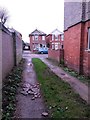
West Southbourne: makeshift surface repair on footpath H09
This is one of seven public footpaths running parallel with and either side of Kimberley Road, serving as rear driveway access to the properties on that road. Complementing the criss-cross arrangements of roads in West Southbourne, they are arranged in the following order:
(northeast side of Kimberley Road)
Castlemain Avenue - footpath H09 - Beaufort Road - footpath H10 - Stamford Road - footpath H13 - Arnewood Road - footpath H14 - Irving Road
(southwest side of Kimberley Road)
Beaufort Road - footpath H11 - Stamford Road - footpath H12 - Arnewood Road - footpath H15 [called Irving Lane] - Irving Road
Here, we look towards Castlemain Avenue on footpath H09, across a part of the surface where a pothole has been levelled with some broken-up slates or chimneypots.
See Image for the view towards us from across the road, and Image for the next view on the path ahead, with links to further photos along the route.
Image: © Chris Downer
Taken: 8 Jan 2017
0.05 miles
4
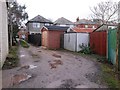
West Southbourne: offset garages on footpath H09
This is one of seven public footpaths running parallel with and either side of Kimberley Road, serving as rear driveway access to the properties on that road. Complementing the criss-cross arrangements of roads in West Southbourne, they are arranged in the following order:
(northeast side of Kimberley Road)
Castlemain Avenue - footpath H09 - Beaufort Road - footpath H10 - Stamford Road - footpath H13 - Arnewood Road - footpath H14 - Irving Road
(southwest side of Kimberley Road)
Beaufort Road - footpath H11 - Stamford Road - footpath H12 - Arnewood Road - footpath H15 [called Irving Lane] - Irving Road
Here, we look along footpath H09 in the direction of Castlemain Avenue, where three garages are set back at slightly different intervals, no doubt easing vehicular access compared to if they were level with each other.
See Image for the view towards us from across the road, and Image for the next view on the path ahead - each with links to further photos along the route.
Image: © Chris Downer
Taken: 8 Jan 2017
0.05 miles
5
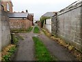
West Southbourne: footpaths H06 and H07 meet
This short public footpath, number H06, leads from Paisley Road behind us to Kimberley Road, ahead. It doubles up as a rear access driveway to houses in both streets, by way of another driveway, footpath H07, which we see turning off to the left to run along the backs of both rows of houses.
See:
Image for the view towards us from across the road ahead;
Image for the next view on path H06 behind us; and
Image for the view along path H07, left.
The last two contain links to further photos on the mentioned routes.
Image: © Chris Downer
Taken: 8 Jan 2017
0.05 miles
6
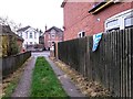
West Southbourne: passing a hanging towel on footpath H06
This short public footpath doubles up as a rear access driveway to houses in Paisley Road (ahead) and Kimberley Road (the next parallel road behind) - a further driveway, footpath H07, turns off to the right just behind us to run along the backs of both rows of houses.
Meanwhile, a towel has been hung to dry over the fence on the right.
See Image for the view along the path from across the road ahead, andImage for the next view on the path behind us, with links to further photos on both mentioned routes.
Image: © Chris Downer
Taken: 8 Jan 2017
0.05 miles
7
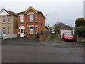
West Southbourne: footpath H06 from Paisley Road
This short public footpath doubles up as a rear access driveway to houses in Paisley Road and Kimberley Road - a further driveway, footpath H07, turns off to the left to run along the backs of both rows of houses.
See Image for the next view on the path ahead, with links to further photos on both mentioned routes.
Image: © Chris Downer
Taken: 8 Jan 2017
0.05 miles
8
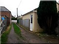
West Southbourne: southeast end of footpath H07
This public footpath is essentially a rear access driveway for properties in Kimberley Road (to the left) and Paisley Road (right). Ahead, the path comes to an end and footpath H06 goes left or right to either road.
The outbuilding on the right has a notice in the window advertising itself as a Pilates studio.
See Image for the next view on the path behind us, and Image for a view towards us from the end of the path ahead - each with links to further photos on the mentioned routes.
Image: © Chris Downer
Taken: 8 Jan 2017
0.05 miles
9
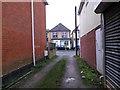
West Southbourne: footpath H11 approaches Beaufort Road
This is one of seven public footpaths running parallel with and either side of Kimberley Road, serving as rear driveway access to the properties on that road. Complementing the criss-cross arrangements of roads in West Southbourne, they are arranged in the following order:
(northeast side of Kimberley Road)
Castlemain Avenue - footpath H09 - Beaufort Road - footpath H10 - Stamford Road - footpath H13 - Arnewood Road - footpath H14 - Irving Road
(southwest side of Kimberley Road)
Beaufort Road - footpath H11 - Stamford Road - footpath H12 - Arnewood Road - footpath H15 [called Irving Lane] - Irving Road
Here, we look along footpath H11 as it reaches Beaufort Road.
See Image for the next view on the path ahead, and Image for the next view behind us, with links to further photos along the routes.
Image: © Chris Downer
Taken: 8 Jan 2017
0.06 miles
10
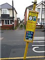
West Southbourne: footpath H11 and a leaning bus stop sign
This is one of seven public footpaths running parallel with and either side of Kimberley Road, serving as rear driveway access to the properties on that road. Complementing the criss-cross arrangements of roads in West Southbourne, they are arranged in the following order:
(northeast side of Kimberley Road)
Castlemain Avenue - footpath H09 - Beaufort Road - footpath H10 - Stamford Road - footpath H13 - Arnewood Road - footpath H14 - Irving Road
(southwest side of Kimberley Road)
Beaufort Road - footpath H11 - Stamford Road - footpath H12 - Arnewood Road - footpath H15 [called Irving Lane] - Irving Road
Here, we look across Beaufort Road from a bus stop with a leaning signpost, along the start of footpath H11.
See Image for the next view on the path ahead, with links to further photos along the routes.
Image: © Chris Downer
Taken: 8 Jan 2017
0.06 miles