IMAGES TAKEN NEAR TO
Ravenscourt Road, BOURNEMOUTH, BH6 5EF
Introduction
This page details the photographs taken nearby to Ravenscourt Road, BH6 5EF by members of the Geograph project.
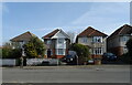
The Geograph project started in 2005 with the aim of publishing, organising and preserving representative images for every square kilometre of Great Britain, Ireland and the Isle of Man.

There are currently over 7.5m images from over14,400 individuals and you can help contribute to the project by visiting https://www.geograph.org.uk
Image Map (Loading...)


Getting Data...Please wait
Leaflet Map data © OpenStreetMap
Images are licensed for reuse under creativecommons.org/licenses/by-sa/2.0
Notes
- Clicking on the map will re-center to the selected point.
- The higher the marker number, the further away the image location is from the centre of the postcode.
Image Listing (137 Images Found)
Images are licensed for reuse under creativecommons.org/licenses/by-sa/2.0
Image
Details
Distance
2
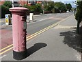
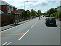
West Southbourne: postbox № BH6 126, Beaufort Road
Looking south along Beaufort Road from the Herberton Road crossroads.
Image: © Chris Downer
Taken: 19 Jul 2008
0.06 miles
3
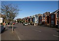
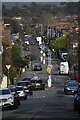
Arnewood Road, West Southbourne
Part of a large residential area set out on a grid-iron pattern, with roads intersecting at right angles, all sloping down towards the Stour.
Image: © Derek Harper
Taken: 10 Mar 2010
0.06 miles
4
West Southbourne, Bournemouth
This is a dense residential area to the east of Bournemouth centre.
Image: © Stuart Buchan
Taken: 28 May 2006
0.07 miles
5
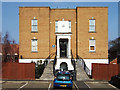
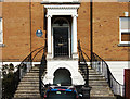
The remains of Stourfield House
The original staircase and portico of a former great mansion that once stood on this site, is all that remains now of Stourfield House. Built 1766 for Edmond Bott, it became a hospital after it was extended in 1898, and renamed Douglas House. Demolished in 1991, a blue plaque on the wall now accompanies these architectural remains to remind us of its history. Grade II listed. More history, and a contemporary photograph of Stourfield House with a contextual view of the surviving staircase and portico: https://www.flickr.com/photos/45065527@N08/5912990452/
Image
Image: © Mike Searle
Taken: 18 Mar 2015
0.07 miles
6
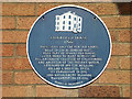
Bournemouth Blue Plaques: No. 18 - Stourfield House staircase and portico
The original C18 staircase and portico of Stourfield House remain at the entrance front of the modern apartments that were built on the site, after it was demolished in 1991. According to the plaque, Mary Bowes the Countess of Strathmore, ancestor of the Queen, once lived here.
Image
Image
Image: © Mike Searle
Taken: 18 Mar 2015
0.08 miles
7
The remains of Stourfield House (2)
The original staircase and portico of Stourfield House, a fine Georgian mansion that once stood on this site (built 1766, demolished 1991).
Image: © Mike Searle
Taken: 18 Mar 2015
0.08 miles
8
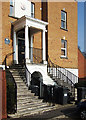
The remains of Stourfield House (3)
The original staircase and portico of Stourfield House, a fine Georgian mansion that once stood on this site (built 1766, demolished 1991).
Image: © Mike Searle
Taken: 18 Mar 2015
0.08 miles