IMAGES TAKEN NEAR TO
Rolls Drive, BOURNEMOUTH, BH6 4NA
Introduction
This page details the photographs taken nearby to Rolls Drive, BH6 4NA by members of the Geograph project.
The Geograph project started in 2005 with the aim of publishing, organising and preserving representative images for every square kilometre of Great Britain, Ireland and the Isle of Man.

There are currently over 7.5m images from over14,400 individuals and you can help contribute to the project by visiting https://www.geograph.org.uk
Image Map (Loading...)


Getting Data...Please wait
Leaflet Map data © OpenStreetMap
Images are licensed for reuse under creativecommons.org/licenses/by-sa/2.0
Notes
- Clicking on the map will re-center to the selected point.
- The higher the marker number, the further away the image location is from the centre of the postcode.
Image Listing (46 Images Found)
Images are licensed for reuse under creativecommons.org/licenses/by-sa/2.0
Image
Details
Distance
1
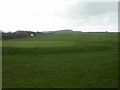
Solent Meads Golf Centre
18 hole golf course, looking towards Hengistbury Head.
Image: © Mike Faherty
Taken: 9 Nov 2008
0.07 miles
2
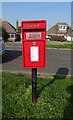
Elizabeth II postbox on Broadway
Postbox No. BH6 158.
Image: © JThomas
Taken: 21 Mar 2022
0.09 miles
3
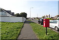
Path beside Broadway
Showing position of Postbox No. BH6 158.
Image: © JThomas
Taken: 21 Mar 2022
0.09 miles
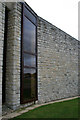
4
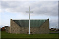
St Nicholas' Southbourne-on-Sea
On the corner of Southbourne Coast Road and Broadway.
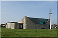
The story of this beautiful modern church starts in 1958 when the land was made available by the Bournemouth Council. The foundation stone was laid in 1961, but the building was not completed until 1971. The large cross to the east was erected in 1977. It is built of Purbeck Stone.
It is a daughter church of the parish church of St Katharine, Southbourne in Image
Image: © David Lally
Taken: 21 Mar 2010
0.10 miles
5
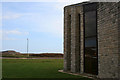
Hengistbury Head and St Nicholas'
On the corner of Southbourne Coast Road and Broadway.
The story of this beautiful modern church starts in 1958 when the land was made available by the Bournemouth Council. The foundation stone was laid in 1961, but the building was not completed until 1971. The large cross to the east was erected in 1977. It is built of Purbeck Stone.
It is a daughter church of the parish church of St Katharine, Southbourne in Image
Image: © David Lally
Taken: 21 Mar 2010
0.10 miles
6
St Nicholas' Southbourne-on-Sea
On the corner of Southbourne Coast Road and Broadway.
The story of this beautiful modern church starts in 1958 when the land was made available by the Bournemouth Council. The foundation stone was laid in 1961, but the building was not completed until 1971. The large cross to the east was erected in 1977. It is built of Purbeck Stone.
It is a daughter church of the parish church of St Katharine, Southbourne in Image
Image: © David Lally
Taken: 21 Mar 2010
0.10 miles
7
Clubhouse, Solent Meads golf course
Clubhouse for 18 hole course just north-west of Hengistbury Head. http://www.bournemouth.gov.uk/Visitors/Outdoor_Activities/SolentMeads.asp
Image: © Mike Faherty
Taken: 9 Nov 2008
0.10 miles
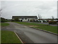
8

Dummies outside St. Katherine's Primary School
There is a right-angled bend in the road outside the school. Two dummies warn of children in one direction and another two in the other direction.
Image: © Robin Webster
Taken: 6 Nov 2016
0.11 miles
9
St Nicholas' Southbourne-on-Sea
On the corner of Southbourne Coast Road and Broadway.
The story of this beautiful modern church starts in 1958 when the land was made available by the Bournemouth Council. The foundation stone was laid in 1961, but the building was not completed until 1971. The large cross to the east was erected in 1977. It is built of Purbeck Stone.
It is a daughter church of the parish church of St Katharine, Southbourne in SZ1491 Image
Image: © David Lally
Taken: 21 Mar 2010
0.11 miles