IMAGES TAKEN NEAR TO
Burtley Road, BOURNEMOUTH, BH6 4AP
Introduction
This page details the photographs taken nearby to Burtley Road, BH6 4AP by members of the Geograph project.
The Geograph project started in 2005 with the aim of publishing, organising and preserving representative images for every square kilometre of Great Britain, Ireland and the Isle of Man.

There are currently over 7.5m images from over14,400 individuals and you can help contribute to the project by visiting https://www.geograph.org.uk
Image Map
Images are licensed for reuse under creativecommons.org/licenses/by-sa/2.0
Notes
- Clicking on the map will re-center to the selected point.
- The higher the marker number, the further away the image location is from the centre of the postcode.
Image Listing (195 Images Found)
Images are licensed for reuse under creativecommons.org/licenses/by-sa/2.0
Image
Details
Distance
1
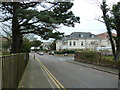
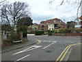
Looking down Wollaston Road towards Burley Road
Image: © Basher Eyre
Taken: 5 Apr 2013
0.04 miles
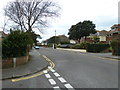
4
Postbox at the junction of Church and Wollaston Roads
Image: © Basher Eyre
Taken: 5 Apr 2013
0.06 miles
5
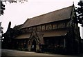
St Katharine, Southbourne
Listed building erected in 1881.
Image: © Michael FORD
Taken: Unknown
0.06 miles
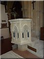
7
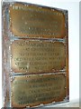
St. Katharine, Southbourne: memorials (2,3,4)
Image: © Basher Eyre
Taken: 5 Apr 2013
0.06 miles
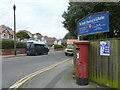
8
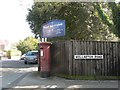
Southbourne: postbox № BH6 194, Church Road
This postbox is outside Image, on the corner of Church and Wollaston Roads.
Image: © Chris Downer
Taken: 20 Sep 2008
0.06 miles
9
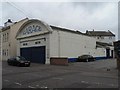
Southbourne: old fashioned garage frontage
Around the other side, on the main road, is a modern showroom with large plate glass – a contrast to the view this side – which has recently closed and been taken over by a bed shop.
Image: © Chris Downer
Taken: 6 Sep 2008
0.06 miles
10
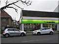
Southbourne: footpath I30 from Belle Vue Road
Looking across Belle Vue Road towards the Co-op, which occupies a former car showroom. A man, whose jacket hood is almost as bright as the Co-op signage, has come out of the shop and is heading down a public footpath to St. Catherine's Road. Perhaps he parked in the Co-op car park - the path is the most direct access from there to the shop.
See Image for the next in a series of photos along the path.
Image: © Chris Downer
Taken: 11 Feb 2017
0.06 miles