IMAGES TAKEN NEAR TO
Southbourne Grove, BOURNEMOUTH, BH6 3RN
Introduction
This page details the photographs taken nearby to Southbourne Grove, BH6 3RN by members of the Geograph project.
The Geograph project started in 2005 with the aim of publishing, organising and preserving representative images for every square kilometre of Great Britain, Ireland and the Isle of Man.

There are currently over 7.5m images from over14,400 individuals and you can help contribute to the project by visiting https://www.geograph.org.uk
Image Map
Images are licensed for reuse under creativecommons.org/licenses/by-sa/2.0
Notes
- Clicking on the map will re-center to the selected point.
- The higher the marker number, the further away the image location is from the centre of the postcode.
Image Listing (139 Images Found)
Images are licensed for reuse under creativecommons.org/licenses/by-sa/2.0
Image
Details
Distance
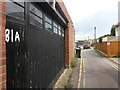
1
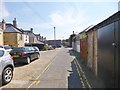
Southbourne Lane East
A narrow lane in three sections serving commercial premises on Southbourne Grove, and residential properties.
Image: © Mike Faherty
Taken: 25 Jul 2014
0.01 miles
2
Southbourne, Wight Bear
Micropub on Southbourne Grove, cunningly semi-hidden by a bus stop - so convenient for routes 1b, 1c & m2. Celebrating its first anniversary, and Bournemouth's second micropub. Internally, a single room, with simple wooden tables alongside wooden benches; service is to table, from a servery and stillage to the rear. Usually, four cask ales are on offer, with a similar number of ciders. Listed in 2017 Good Beer Guide. https://bearbeerfamily.co.uk/the-wight-bear/ The pub is named after an outline of a bear, visible from the nearby Overcliff.
Image: © Mike Faherty
Taken: 20 Oct 2016
0.02 miles
3
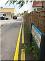
Southbourne: sign for Southbourne Lane East
Southbourne Lane is split into three sections - West, Central and East - and is essentially a back alley providing rear accesses to shops and flats in Southbourne Grove (parallel to the left).
Each section is also a public footpath - Southbourne Lane East is footpath H03 and it links Grand Avenue (here) with Pine Avenue, and is longer than the other two combined.
See Image for a view across Grand Avenue to here from behind us, and Image for a view a little further ahead.
Image: © Chris Downer
Taken: 25 Jun 2016
0.02 miles
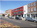
4
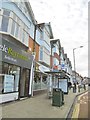
Southbourne Grove
Butchers, bakers, ... couldn't see any candle-stick makers, but Southbourne Grove looks as if it's surviving well as a local shopping centre.
Image: © Mike Faherty
Taken: 18 Feb 2009
0.03 miles
5
Southbourne: footpath H03 passes the rear of 81 Southbourne Grove
Southbourne Lane is split into three sections - West, Central and East - and is essentially a back alley providing rear accesses to shops and flats in Southbourne Grove (parallel to the left).
Each section is also a public footpath - Southbourne Lane East is footpath H03 and it links Grand Avenue (behind) with Pine Avenue (ahead), and is longer than the other two combined.
See Image for a view to here from Grand Avenue (behind us), and Image for a view further on, beyond the kink ahead.
Image: © Chris Downer
Taken: 25 Jun 2016
0.03 miles
6
Southbourne, Sainsbury's Local
Store on Southbourne Grove.
Image: © Mike Faherty
Taken: 25 Jul 2014
0.03 miles
7

Southbourne: footpath H05 to New Park Road
A narrow public footpath between two tall buildings, leading from Southbourne Grove to New Park Road, which runs behind.
See Image for the next view along the path.
Image: © Chris Downer
Taken: 21 Jul 2016
0.04 miles
8
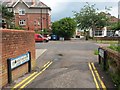
Southbourne: Southbourne Lane Central becomes Southbourne Lane East
Southbourne Lane is split into three sections - West, Central and East - and is essentially a back alley providing rear accesses to shops and flats in Southbourne Grove (parallel to the left).
Each section is also a public footpath - Southbourne Lane Central is footpath H02 and it links Chestnut Avenue, behind us, with Grand Avenue, here.
See Image for the view towards us from the pavement ahead, and Image for a view along the East segment from just ahead of us.
Image: © Chris Downer
Taken: 25 Jun 2016
0.04 miles
9
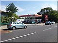
Southbourne, Murco
Service station and Costcutter store on Southbourne Grove.
Image: © Mike Faherty
Taken: 25 Jul 2014
0.04 miles
10

Southbourne: midway along footpath H05
This public footpath doubles as a bin-store access for the neighbouring shops (and flats above) on Southbourne Grove.
See Image for the view from the end of the path behind us, and Image for the emergence onto New Park Road ahead.
Image: © Chris Downer
Taken: 21 Jul 2016
0.04 miles