IMAGES TAKEN NEAR TO
Southbourne Road, BOURNEMOUTH, BH6 3RJ
Introduction
This page details the photographs taken nearby to Southbourne Road, BH6 3RJ by members of the Geograph project.
The Geograph project started in 2005 with the aim of publishing, organising and preserving representative images for every square kilometre of Great Britain, Ireland and the Isle of Man.

There are currently over 7.5m images from over14,400 individuals and you can help contribute to the project by visiting https://www.geograph.org.uk
Image Map (Loading...)


Getting Data...Please wait
Leaflet Map data © OpenStreetMap
Images are licensed for reuse under creativecommons.org/licenses/by-sa/2.0
Notes
- Clicking on the map will re-center to the selected point.
- The higher the marker number, the further away the image location is from the centre of the postcode.
Image Listing (136 Images Found)
Images are licensed for reuse under creativecommons.org/licenses/by-sa/2.0
Image
Details
Distance
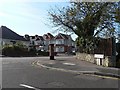
1
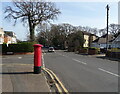
Southbourne Road
Showing position of Postbox No. BH6 124.
Image: © JThomas
Taken: 21 Mar 2022
0.02 miles
2
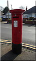
Edward VII postbox on Southbourne Road
Postbox No. BH6 124.
Image: © JThomas
Taken: 21 Mar 2022
0.03 miles
3
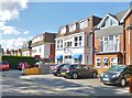
Southbourne Grove Hotel
On, well, Southbourne Grove: http://www.southbournegrovehotel.co.uk/
Image: © Mike Faherty
Taken: 10 Aug 2014
0.03 miles
4
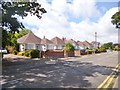
Southbourne, bungalows
On Southbourne Road.
Image: © Mike Faherty
Taken: 10 Aug 2014
0.03 miles
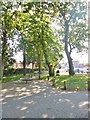
5

Southbourne: footpath H17 meets Southbourne Road
A small triangular green occupies the wedge-shaped space at the convergence of Southbourne Road and Southbourne Grove - the latter is the main shopping street in Southbourne and is behind us.
The short path, cutting the biggest chunk of the corner off, is public footpath number H17, on which we are standing.
See Image for the view behind us towards Southbourne Grove.
Image: © Chris Downer
Taken: 21 Jul 2016
0.03 miles
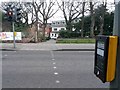
6
West Southbourne: postbox № BH6 124, Southbourne Road
An Edward VII-reign box by the junction with Arnewood Road.
Image: © Chris Downer
Taken: 20 Sep 2008
0.03 miles
7
Southbourne Green
A small wedge-shaped piece of open space between Southbourne Road and Southbourne Grove.
Image: © Mike Faherty
Taken: 25 Jul 2014
0.04 miles
8
Southbourne: footpath H17 from across Southbourne Grove
The short public footpath ahead cuts the acute corner of Southbourne Grove and Southbourne Road, which has a small triangular public green on it. This end, on the main shopping street Southbourne Grove, conveniently comes out right by a pedestrian crossing.
See Image for the next photo on the footpath.
Image: © Chris Downer
Taken: 11 Feb 2017
0.04 miles
9

Southbourne: footpath H17 from Southbourne Road
A small triangular green occupies the wedge-shaped space at the convergence of Southbourne Road and Southbourne Grove - the latter is the main shopping street in Southbourne and is seen ahead of us.
The short path, cutting the biggest chunk of the corner off, is public footpath number H17, along which we are looking.
See Image for a view from further along the path, and Image for the view onto Southbourne Road behind us.
Image: © Chris Downer
Taken: 21 Jul 2016
0.04 miles
10
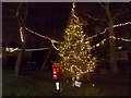
Southbourne: Santa?s postbox on the green
This Christmas tree occupies the long, thin triangular green where Southbourne Grove meets Southbourne Road. A postbox has been installed in front of it, for letters to Santa. Apparently, items which had been posted here by 6 December were likely to get a reply from Santa himself.
Image: © Chris Downer
Taken: 18 Dec 2014
0.05 miles