IMAGES TAKEN NEAR TO
Southbourne Overcliff Drive, BOURNEMOUTH, BH6 3NW
Introduction
This page details the photographs taken nearby to Southbourne Overcliff Drive, BH6 3NW by members of the Geograph project.
The Geograph project started in 2005 with the aim of publishing, organising and preserving representative images for every square kilometre of Great Britain, Ireland and the Isle of Man.

There are currently over 7.5m images from over14,400 individuals and you can help contribute to the project by visiting https://www.geograph.org.uk
Image Map (Loading...)


Getting Data...Please wait
Leaflet Map data © OpenStreetMap
Images are licensed for reuse under creativecommons.org/licenses/by-sa/2.0
Notes
- Clicking on the map will re-center to the selected point.
- The higher the marker number, the further away the image location is from the centre of the postcode.
Image Listing (105 Images Found)
Images are licensed for reuse under creativecommons.org/licenses/by-sa/2.0
Image
Details
Distance
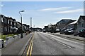
2
Southbourne, Dalvey House
Care/residential home on Belle Vue Road: http://www.dalveyhouse.co.uk/
Image: © Mike Faherty
Taken: 13 Aug 2014
0.04 miles
3
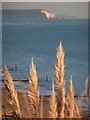
Southbourne: view towards the Isle of Wight
A view towards The Needles, on the Isle of Wight, from one of the back gardens of Southbourne Overcliff Drive.
Image: © Chris Downer
Taken: 11 Nov 2012
0.05 miles
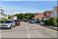
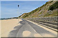
5
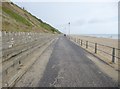
Southbourne Promenade
Extending under various names from Sandbanks to Wick.
Image: © Mike Faherty
Taken: 26 Aug 2014
0.06 miles
6
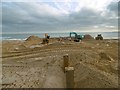
Southbourne, groyne replacement d)
Part of a long-term programme to replace Bournemouth's groynes. In this stage, eight are being worked on. Here, sand is being excavated, to allow the planks to be attached. http://www.bournemouth.gov.uk/AttractionsLeisure/BeachesandWaterfront/BeachManagementScheme/BeachManagementScheme.aspx
Image: © Mike Faherty
Taken: 13 Mar 2017
0.06 miles
7
Southbourne, groyne replacement c)
Part of a long-term programme to replace Bournemouth's groynes; in this stage, eight are being worked on. Sand is being excavated, to allow planks to be inserted. http://www.bournemouth.gov.uk/AttractionsLeisure/BeachesandWaterfront/BeachManagementScheme/BeachManagementScheme.aspx
Image: © Mike Faherty
Taken: 13 Mar 2017
0.06 miles
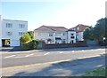
8
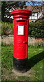
George V postbox on Belle Vue Road
Postbox No. BH6 192.
Image: © JThomas
Taken: 21 Mar 2022
0.07 miles
10
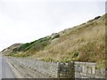
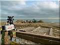
Southbourne, cliff
Between Southbourne Overcliff Drive and Southbourne Promenade. Most flowers have gone over, except the occasional sea carrot, wild radish, evening primrose or seaside daisy, all helping to bind together the underlying sand and clay.
Image: © Mike Faherty
Taken: 26 Aug 2014
0.07 miles