IMAGES TAKEN NEAR TO
St. Annes Avenue, BOURNEMOUTH, BH6 3JR
Introduction
This page details the photographs taken nearby to St. Annes Avenue, BH6 3JR by members of the Geograph project.
The Geograph project started in 2005 with the aim of publishing, organising and preserving representative images for every square kilometre of Great Britain, Ireland and the Isle of Man.

There are currently over 7.5m images from over14,400 individuals and you can help contribute to the project by visiting https://www.geograph.org.uk
Image Map (Loading...)


Getting Data...Please wait
Leaflet Map data © OpenStreetMap
Images are licensed for reuse under creativecommons.org/licenses/by-sa/2.0
Notes
- Clicking on the map will re-center to the selected point.
- The higher the marker number, the further away the image location is from the centre of the postcode.
Image Listing (30 Images Found)
Images are licensed for reuse under creativecommons.org/licenses/by-sa/2.0
Image
Details
Distance
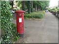
1
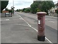
Tuckton: postbox № BH6 219, Cranleigh Road
This one hasn't seen a paintbrush for a while!
Image: © Chris Downer
Taken: 19 Jul 2008
0.05 miles
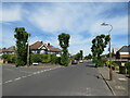
2
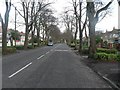
Tuckton: Carbery Avenue
An attractive avenue of desirable houses in the Tuckton area of Bournemouth. It is a relatively busy road, providing good access from Southbourne to the river crossing at Tuckton Bridge.
Image: © Chris Downer
Taken: 12 Jan 2008
0.11 miles
3
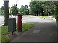
Tuckton: postbox № BH6 232, Carbery Avenue
Alongside this postbox, by the crossroads of Carbery Avenue and Seafield Road, is a drop-box where the postman can store the morning's deliveries for neighbouring streets.
Image: © Chris Downer
Taken: 19 Jul 2008
0.12 miles
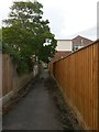
4
Tuckton: footpath I16 to Glenroyd Gardens
This public footpath runs between two of the upmarket houses of Carbery Avenue and leads to the dead end of the similarly desirable Glenroyd Gardens.
See Image for the next picture along the path, and links to further photos on the route.
Image: © Chris Downer
Taken: 24 Sep 2016
0.12 miles
5
Tuckton: postbox № BH6 257, Carbery Avenue
A George V-reign box in this desirable leafy avenue.
Image: © Chris Downer
Taken: 19 Jul 2008
0.13 miles
6
Tuckton: footpath I16 heads for Carbery Avenue
This short public footpath leads from the dead end of Glenroyd Gardens onto the main Carbery Avenue, ahead.
See Image for the view up the path from the end ahead, and Image for the next picture on the path behind us, and links to further photos along the route.
Image: © Chris Downer
Taken: 24 Sep 2016
0.13 miles
7
Verona Avenue, Southbourne
Verona Avenue is a minor residential road in Southbourne, in the eastern suburbs of Bournemouth.
In this image, a pigeon is perched on the street lamp to the right.
Image: © Malc McDonald
Taken: 21 Jun 2022
0.13 miles
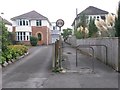
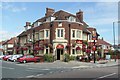
8
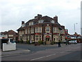
Tuckton, The Athelstan
Pub at the junction of Cranleigh and Athelstan Roads, dated 1931 on a foundation stone. Internally, central bar, with drinking and eating areas on three sides. Cask ales on offer at my visit: Ringwood Best, Boondoggle & Fortyniner. For some customer comments, see http://www.beerintheevening.com/pubs/s/27/2752/Athelstan_Arms/Tuckton
Image: © Mike Faherty
Taken: 5 May 2010
0.13 miles
9
Tuckton: The Athelstan
One of several Eldgridge Pope & Co. pubs which have been modernised and dropped part of their names – this was originally the Athelstan Arms but the Arms has been dropped. It is on the corner of Cranleigh and Athelstan Roads.
Image: © Chris Downer
Taken: 2 Feb 2008
0.15 miles
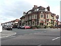
10
The Athelstan at Tuckton
This traditional, early 20th century pub is at the junction of Cranleigh Road and Athelstan Road in west Tuckton.
Image: © mike smith
Taken: 13 Aug 2007
0.15 miles