IMAGES TAKEN NEAR TO
Belle Vue Road, BOURNEMOUTH, BH6 3EJ
Introduction
This page details the photographs taken nearby to Belle Vue Road, BH6 3EJ by members of the Geograph project.
The Geograph project started in 2005 with the aim of publishing, organising and preserving representative images for every square kilometre of Great Britain, Ireland and the Isle of Man.

There are currently over 7.5m images from over14,400 individuals and you can help contribute to the project by visiting https://www.geograph.org.uk
Image Map (Loading...)


Getting Data...Please wait
Leaflet Map data © OpenStreetMap
Images are licensed for reuse under creativecommons.org/licenses/by-sa/2.0
Notes
- Clicking on the map will re-center to the selected point.
- The higher the marker number, the further away the image location is from the centre of the postcode.
Image Listing (189 Images Found)
Images are licensed for reuse under creativecommons.org/licenses/by-sa/2.0
Image
Details
Distance
1
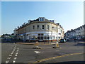
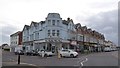
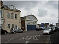
Southbourne, The Hub
At the corner of Belle Vue and St. Catherines Roads, a recently opened cultural centre offering artistic, sporting and leisure activities; formerly Bradleys Restaurant. http://www.southbourne.net/hub
Image: © Mike Faherty
Taken: 11 Feb 2012
0.02 miles
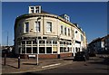
2
Mint Barbers, Southbourne
The same road junction as in Image, but the business has changed to a barber's shop
Image: © David Smith
Taken: 25 Jan 2018
0.02 miles
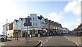
3
Bradley's Restaurant, Southbourne
Occupying the rounded end of a building at Southbourne Cross Roads, between St Catherine's Road (right) and Belle Vue road.
Image: © Derek Harper
Taken: 10 Mar 2010
0.02 miles
4
Southbourne, surfing centre
On Overcliff Drive, next to Southbourne Beach. http://www.bournemouth-surfing.co.uk/
Image: © Mike Faherty
Taken: 27 May 2010
0.03 miles
5
The Shabby Chic Shack, Southbourne
The shop is at the end of a terrace of small shops; of some architectural interest are the large windows above each one, presumably for the flat above the shop
Image: © David Smith
Taken: 29 Mar 2017
0.03 miles
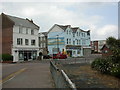
6
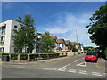
Twynham Road, Southbourne
Twynham Road is a minor residential road in Southbourne, in the eastern suburbs of Bournemouth.
Image: © Malc McDonald
Taken: 21 Jun 2022
0.04 miles
7
Southbourne, Southbourne Cliffs
Pub at junction Belle Vue & Seafield Roads. Internally, bar to left, drinking areas to right; two pool tables. No cask ale available at my visit. For some customer reviews, see http://www.beerintheevening.com/pubs/s/28/2892/Southbourne_Cliffs/Southbourne
Image: © Mike Faherty
Taken: 3 Jun 2009
0.04 miles
8
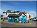
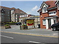
Colourful toilet block, Southbourne
A public toilet block with a colourful mural in Southbourne, in the eastern suburbs of Bournemouth. The garage frontage in the background to the right is notable.
Image: © Malc McDonald
Taken: 21 Jun 2022
0.04 miles
9
Southbourne, former garage
1920-30s building on St. Catherine's Road; now part of a bed shop.
Image: © Mike Faherty
Taken: 27 May 2010
0.04 miles
10
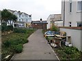
Southbourne: footpath I31 approaches St. Catherine?s Road
This public footpath comes alongside the end shop in St. Catherine's Road (to our right), and just behind us joins the rear access driveway for the shops.
See Image for the view towards us from ahead, and Image for the next photo behind on the path behind us, with links to further photos along the route.
Image: © Chris Downer
Taken: 11 Feb 2017
0.04 miles