IMAGES TAKEN NEAR TO
Cromwell Road, BOURNEMOUTH, BH5 2JW
Introduction
This page details the photographs taken nearby to Cromwell Road, BH5 2JW by members of the Geograph project.
The Geograph project started in 2005 with the aim of publishing, organising and preserving representative images for every square kilometre of Great Britain, Ireland and the Isle of Man.

There are currently over 7.5m images from over14,400 individuals and you can help contribute to the project by visiting https://www.geograph.org.uk
Image Map (Loading...)


Getting Data...Please wait
Leaflet Map data © OpenStreetMap
Images are licensed for reuse under creativecommons.org/licenses/by-sa/2.0
Notes
- Clicking on the map will re-center to the selected point.
- The higher the marker number, the further away the image location is from the centre of the postcode.
Image Listing (133 Images Found)
Images are licensed for reuse under creativecommons.org/licenses/by-sa/2.0
Image
Details
Distance
1

Pokesdown United Reformed Church
Grade 2 listed building erected in 1820.
Image: © Michael FORD
Taken: Unknown
0.03 miles
2

Southbourne: Hampden Lane
A narrow dead-end side-street off Southbourne Road, with a rural feel despite being surrounded by suburbia.
See Image for a picture of one of the houses along the lane, although there are some modern-ish bungalows too.
Image: © Chris Downer
Taken: 21 Jul 2016
0.04 miles
3
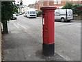
Pokesdown: postbox № BH5 137, Ashbourne Road
An Edward VII-reign specimen.
Image: © Chris Downer
Taken: 25 Oct 2008
0.04 miles
4
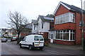
Houses on Sunnyhill Rd
The houses in this part of Bournemouth are mostly red brick Victorian. This is looking toward Southbourne Grove
Image: © Nigel Mykura
Taken: 6 Mar 2019
0.04 miles
5

Southbourne: attractive house on Hampden Lane
Looking along Hampden Lane, a surprisingly rural looking dead-end side-street in the midst of Bournemouth's suburbia. The house here is of a traditional character, while most of the surrounding street have more uniformly built houses of the early 20th century.
See Image for a view of the last house in the lane, and Image for the entrance to the lane behind us.
Image: © Chris Downer
Taken: 21 Jul 2016
0.06 miles
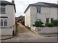
6

Southbourne: round the bend and onto Hampden Lane on footpath H01
This narrow passageway forms a public footpath to the dead end of Hampden Lane, a surprisingly rural little side-street now much hemmed in by Bournemouth's suburbia.
Here, we look past the lamppost at the bend midway along the footpath, towards the emergence onto the dead end of Hampden Lane.
See Image for the view towards the path from the road ahead, and Image for the next view on the path behind us - with links to further photos along the route.
Image: © Chris Downer
Taken: 21 Jul 2016
0.07 miles
7

Southbourne: footpath H01 and the Old Vicarage
Looking at the very end of Hampden Lane, a surprisingly rural looking side-street in the midst of Bournemouth's suburbia. The end house is the Old Vicarage, presumably that of All Saints' church. Just to the left of its gateway is a public footpath running downhill to Stourvale Road.
See Image for the next view on the path ahead, and Image for another house on Hampden Lane, a little way behind us.
Image: © Chris Downer
Taken: 21 Jul 2016
0.07 miles
8
Pokesdown: Stourvale Place from Wyncombe Road
Stourvale Place is a little gravel lane off Stourvale Road, which has a few houses along it (seen in the background). It forms public footpath number G08 and turns a corner to come out on Wyncombe Road, which is where we are standing now.
The sign says "leading to Cromwell Place", but it is only as a footpath that Cromwell Place meets the lane (see Image).
See Image for the next view on the lane, with links to further pictures along both routes.
Image: © Chris Downer
Taken: 21 Jul 2016
0.08 miles
9

Southbourne: footpath H01 to Hampden Lane
This narrow passageway forms a public footpath to the dead end of Hampden Lane, a surprisingly rural little side-street now much hemmed in by Bournemouth's suburbia.
See Image for the next view on the path, and links to further photos all along its route and along Hampden Lane itself.
Image: © Chris Downer
Taken: 21 Jul 2016
0.08 miles
10

Southbourne: approaching the bend on footpath H01
This narrow passageway forms a public footpath to the dead end of Hampden Lane, a surprisingly rural little side-street now much hemmed in by Bournemouth's suburbia.
See Image for the view on the path behind us, and Image for the next view ahead - with links to further photos along its route and along Hampden Lane itself.
Image: © Chris Downer
Taken: 21 Jul 2016
0.08 miles