IMAGES TAKEN NEAR TO
Seabourne Road, BOURNEMOUTH, BH5 2HA
Introduction
This page details the photographs taken nearby to Seabourne Road, BH5 2HA by members of the Geograph project.
The Geograph project started in 2005 with the aim of publishing, organising and preserving representative images for every square kilometre of Great Britain, Ireland and the Isle of Man.

There are currently over 7.5m images from over14,400 individuals and you can help contribute to the project by visiting https://www.geograph.org.uk
Image Map (Loading...)


Getting Data...Please wait
Leaflet Map data © OpenStreetMap
Images are licensed for reuse under creativecommons.org/licenses/by-sa/2.0
Notes
- Clicking on the map will re-center to the selected point.
- The higher the marker number, the further away the image location is from the centre of the postcode.
Image Listing (161 Images Found)
Images are licensed for reuse under creativecommons.org/licenses/by-sa/2.0
Image
Details
Distance
1
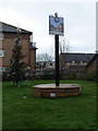
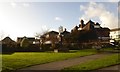
Pokesdown: sign and Christmas tree on Pokesdown Green
Pokesdown Green is a small area by the road junction at the railway station, and many moons ago was occupied by a fire station. It has recently seen the transformation from grotty street corner to pleasant green, and its centrepiece is this 'village sign' style sign depicting an early 20th-century view of the main Christchurch Road, complete with trams.
Image: © Chris Downer
Taken: 5 Jan 2013
0.03 miles
2
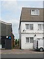
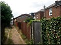
Pokesdown: Cromwell Place from Seabourne Road
Cromwell Place is a little passageway running through from the main Seabourne Road to Stourvale Place, which is itself a gravel lane. There are 5 residential properties along the lane, arranged as a little offshoot path from it.
Cromwell Place forms public footpath number G09, and we see it here from the Seabourne end as a man has just unloaded three large pieces of chipboard from the white van - he can be seen carrying one of them along the path while the other two are leaning against the former shop.
See Image for the next view along the path, with links to further photos along its route.
Image: © Chris Downer
Taken: 21 Jul 2016
0.03 miles
3
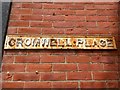
Pokesdown: cast iron name sign on Cromwell Place
Cromwell Place is a little passageway running through from the main Seabourne Road to Stourvale Place, which is itself a gravel lane. There are 5 residential properties along the lane, arranged as a little offshoot path from it.
Cromwell Place forms public footpath number G09.
Here, we take a close look at the name sign at the Seabourne Road end - a traditional old cast iron sign of a type which survive in quite large numbers still. They generally have modern versions nearby, kept presumably as mere nods to vintage - but there are no modern ones just here.
See Image for the view along the path from Seabourne Road, and Image for the view emerging onto Seabourne Road, with links to further photos along the route.
Image: © Chris Downer
Taken: 21 Jul 2016
0.03 miles
4
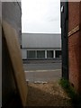
Pokesdown: southwestern end of Cromwell Place
Cromwell Place is a little passageway running through from the main Seabourne Road to Stourvale Place, which is itself a gravel lane. There are 5 residential properties along the lane, arranged as a little offshoot path from it.
Cromwell Place forms public footpath number G09, and we see it here as it emerges onto Seabourne Road. A close-up of the sign on the right can be seen here: Image
See Image for the view along the path from across the road (and an explanation of the chipboard being there), and Image for the next view on the path behind us - with links to further photos along its route.
Image: © Chris Downer
Taken: 21 Jul 2016
0.03 miles
5
Pokesdown town sign, Pokesdown Green, Seabourne Road
Image: © David Smith
Taken: 25 Jan 2018
0.04 miles
6
Pokesdown: Cromwell Place passes some back yards
Cromwell Place is a little passageway running through from the main Seabourne Road to Stourvale Place, which is itself a gravel lane. There are 5 residential properties along the lane, arranged as a little offshoot path from it.
Cromwell Place forms public footpath number G09, and we look along it here towards the Seabourne end, with the back yards of Stourvale Road on our right.
As can be gauged from the gravel tracks, it is just - but I reckon only just - possible to get an average-sized car along here.
See Image for the end of the path ahead, and Image for the next view behind us, with links to further photos along its route.
Image: © Chris Downer
Taken: 21 Jul 2016
0.04 miles
7
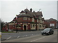
Pokesdown, The Bell
Imposing Victorian pub opposite Pokesdown station Image Externally, intricate roofs, walls partially hung with scalloped tiles, etched glass windows. Internally, rectangular bar with drinking & eating areas left, front & right; music, TV, pool & garden. Cask ales on offer at my visit: Ringwood Best, Marston's Sweet Chariot. For some customer reviews, see http://www.beerintheevening.com/pubs/s/23/2321/Bell/Pokesdown
Image: © Mike Faherty
Taken: 24 Feb 2009
0.05 miles
8
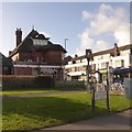
The Bell, Pokesdown
Decorated with a Christmas bow, eleven months early
Image: © David Smith
Taken: 25 Jan 2018
0.05 miles
9
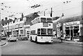
Bournemouth trolleybus 274 at Pokesdown Station ? 1969
There were two trolleybus routes between Bournemouth and Christchurch, via Iford (20) or Southbourne (21), which split at this point.
Bournemouth Corporation 274 is a Sunbeam MF2B with Weymann bodywork, new in 1959. This was the last day of normal trolleybus operation in Bournemouth, so at only 10 years old it was far from life-expired.
This is one of a series of views featuring buses in the 60s, 70s, and 80s. http://www.geograph.org.uk/search.php?i=137652761
Image: © Alan Murray-Rust
Taken: 19 Apr 1969
0.05 miles
10
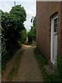
Pokesdown: passing a door on Cromwell Place
Cromwell Place is a little passageway running through from the main Seabourne Road to Stourvale Place, which is itself a gravel lane. There are 5 residential properties along the lane, arranged as a little offshoot path from it.
Cromwell Place forms public footpath number G09, and we see it here as it passes alongside the first of its houses - the other four are just off to the right ahead, while the path itself continues ahead.
See Image for the view of the front of the house, and Image for the view behind us - each with links to further photos along its route.
Image: © Chris Downer
Taken: 21 Jul 2016
0.05 miles