IMAGES TAKEN NEAR TO
Harvey Road, BOURNEMOUTH, BH5 2BE
Introduction
This page details the photographs taken nearby to Harvey Road, BH5 2BE by members of the Geograph project.
The Geograph project started in 2005 with the aim of publishing, organising and preserving representative images for every square kilometre of Great Britain, Ireland and the Isle of Man.

There are currently over 7.5m images from over14,400 individuals and you can help contribute to the project by visiting https://www.geograph.org.uk
Image Map
Images are licensed for reuse under creativecommons.org/licenses/by-sa/2.0
Notes
- Clicking on the map will re-center to the selected point.
- The higher the marker number, the further away the image location is from the centre of the postcode.
Image Listing (123 Images Found)
Images are licensed for reuse under creativecommons.org/licenses/by-sa/2.0
Image
Details
Distance
1
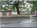
Boscombe: postbox № BH5 23, Parkwood Road
A wall-mounted George VI-reign postbox, with the Corpus Christi church hall to the right.
Image: © Chris Downer
Taken: 6 Sep 2008
0.07 miles
2
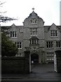
Boscombe: former Convent of the Cross
This is the central entrance of the former convent, which is now used as the Image
Image: © Chris Downer
Taken: 6 Sep 2008
0.07 miles
3
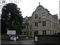
Boscombe: Anglo European College of Chiropractic
The college occupies what was once the Convent of the Cross; the building straddles the gridline and this is the northern end.
Image: © Chris Downer
Taken: 6 Sep 2008
0.07 miles
4
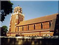
Corpus Christi, Boscombe
Grade 2 listed building erected in 1895.
Image: © Michael FORD
Taken: Unknown
0.08 miles
5
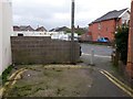
Boscombe East: footpath G07 from Colville Road
Looking across the right-angled bend along Colville Road, where a short public footpath leads to the end of Colonnade Road. It is literally just a couple of yards between the two carriageways but the public right of way measures in at 18 metres, so it must include the first stretch of Colonnade Road.
See Image for a photo looking towards us from along the path.
Image: © Chris Downer
Taken: 25 Feb 2017
0.09 miles
6
Boscombe East: footpath G07 arrives on Colville Road
Looking from the end of Colonnade Road onto Colville Road; the route between the two is a public footpath. It is literally just a couple of yards between the two carriageways but the public right of way measures in at 18 metres, so it must include the stretch of Colonnade Road on which we are standing.
See Image for a photo looking towards us from along the path, and Image for the view from farther behind us.
Image: © Chris Downer
Taken: 25 Feb 2017
0.09 miles
7
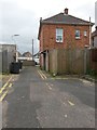
Boscombe East: the end of Colonnade Road
Colonnade Road is essentially a rear access driveway for a parade of shops in Christchurch Road. It comes to an end just in front of us, but there is access onto Colville Road for pedestrians, a route that is officially a public footpath. It is literally just a couple of yards between the two carriageways but the public right of way measures in at 18 metres, so it must include the stretch of Colonnade Road just in front of us, alongside the house and its garden.
The old double yellow lines are still evident in the centre of the roadway here, so the road has obviously been widened at some point, perhaps to give more turning space for the last couple of back yards.
See Image for a picture of the emergence onto Colville Road ahead.
Image: © Chris Downer
Taken: 25 Feb 2017
0.09 miles
8
Queensland Road, Pokesdown
What was the reason for choosing this name for the residential road?
Image: © David Smith
Taken: 25 Jan 2018
0.10 miles
9
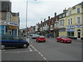
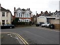
Christchurch Road, Boscombe (1)
This picture was taken at the junction of Somerset Road, photographer was facing Pokesdown Station.
Image: © Danny P Robinson
Taken: 11 Mar 2006
0.10 miles
10
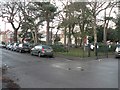
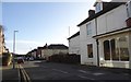
Boscombe: St. James?s Square
A small square in suburban Boscombe, and Bournemouth’s only truly square ‘Square’.
Image: © Chris Downer
Taken: 23 Dec 2007
0.10 miles