IMAGES TAKEN NEAR TO
Browning Avenue, BOURNEMOUTH, BH5 1NS
Introduction
This page details the photographs taken nearby to Browning Avenue, BH5 1NS by members of the Geograph project.
The Geograph project started in 2005 with the aim of publishing, organising and preserving representative images for every square kilometre of Great Britain, Ireland and the Isle of Man.

There are currently over 7.5m images from over14,400 individuals and you can help contribute to the project by visiting https://www.geograph.org.uk
Image Map
Images are licensed for reuse under creativecommons.org/licenses/by-sa/2.0
Notes
- Clicking on the map will re-center to the selected point.
- The higher the marker number, the further away the image location is from the centre of the postcode.
Image Listing (129 Images Found)
Images are licensed for reuse under creativecommons.org/licenses/by-sa/2.0
Image
Details
Distance
1

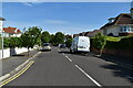
Woodland Walk Southbourne
Woodland Walk link Boscombe and Southbourne via Boscombe Overcliff Drive, both Bournemouth suburbs. It was created in 1872 by Viscount Portman as an access road to his summer residence, Wentworth Lodge.
In more recent times the area has been made more attractive, by being designated as a nature reserve, with the sum of £185,000 allocated to the project by BCP council. This included the provision of carved benches together with a variety of amazing sculptures by the chainsaw sculptor, Tom Harvey, a raised wildlife pond, new entrance stonework with refurbished gates, a plethora of new signage, and tree planting.
Image: © Mike Searle
Taken: 10 Nov 2025
0.06 miles
4
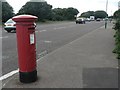
Boscombe: postbox № BH5 260, Boscombe Overcliff Drive
The Overcliff Drive is the broad clifftop road across eastern Bournemouth. Just west of here, Boscombe Overcliff Drive becomes Southbourne Overcliff Drive and marks the barely defined border between those two suburbs.
Image: © Chris Downer
Taken: 19 Jul 2008
0.07 miles
5
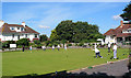
Boscombe Cliff Bowling Club, Woodlands Avenue
The club house (right) was built in 1927 and today is open to the public as a cafe.
Image: © Peter Facey
Taken: 8 Sep 2006
0.08 miles
6

Boscombe Cliff Bowling Club
On Boscombe Overcliff Drive; founded, according to the flag, in 1904, with pavilion and café. http://www.boscombecliffbowlsclub.co.uk/
Image: © Mike Faherty
Taken: 14 Jul 2012
0.10 miles