IMAGES TAKEN NEAR TO
Bournewood Drive, BOURNEMOUTH, BH4 9JP
Introduction
This page details the photographs taken nearby to Bournewood Drive, BH4 9JP by members of the Geograph project.
The Geograph project started in 2005 with the aim of publishing, organising and preserving representative images for every square kilometre of Great Britain, Ireland and the Isle of Man.

There are currently over 7.5m images from over14,400 individuals and you can help contribute to the project by visiting https://www.geograph.org.uk
Image Map (Loading...)


Getting Data...Please wait
Leaflet Map data © OpenStreetMap
Images are licensed for reuse under creativecommons.org/licenses/by-sa/2.0
Notes
- Clicking on the map will re-center to the selected point.
- The higher the marker number, the further away the image location is from the centre of the postcode.
Image Listing (114 Images Found)
Images are licensed for reuse under creativecommons.org/licenses/by-sa/2.0
Image
Details
Distance
1
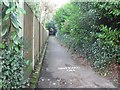
Bournemouth: higher footpath to Branksome Wood Road
Branksome Wood Road runs parallel with much of the Gardens and has access to them by way of two footpaths, this being the more upstream.
Image: © Chris Downer
Taken: 27 Jan 2008
0.02 miles
2

Bournemouth Gardens: start of elevated walkway
The start of Image
Image: © Chris Downer
Taken: 12 Jan 2008
0.03 miles
3
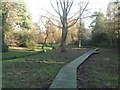
Bournemouth Gardens: second raised walkway
The Gardens has two sections of raised walkway – travelling downstream, this is the second and, unlike the first, is on the southern side of the stream.
Image: © Chris Downer
Taken: 27 Jan 2008
0.04 miles
4

Bournemouth Gardens: footbridge and steps
Another view across the Bourne Stream, about ⅓ of the way down the Gardens on their 2½-mile journey to Bournemouth pier. In the background are steps to Surrey Road
Image: © Chris Downer
Taken: 12 Jan 2008
0.05 miles
5
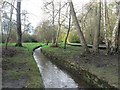
Bournemouth Gardens: stream among trees
The further upstream one goes in the Gardens, the less formal and more natural it feels. Here, we look upstream with the Image on the opposite side.
Image: © Chris Downer
Taken: 12 Jan 2008
0.05 miles
6
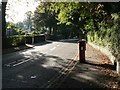
Bournemouth: postbox № BH4 37, Branksome Wood Road
A George V-reign postbox in this leafy suburb. Attached to the back is a drop box (see below), just visible here.
Image: © Chris Downer
Taken: 20 Sep 2008
0.06 miles
7
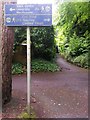
Westbourne: footpath A09 leaves the Upper Gardens
We look along this public footpath to Surrey Road, from the Upper Gardens, whose southern edge is termed a Greenway - a shared foot and cycle path (hence the sign, with its green G symbol).
See Image for a view midway along the path, up the steps which can just be seen in the distance.
Image: © Chris Downer
Taken: 30 Jun 2016
0.06 miles
8
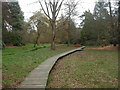
Boardwalk, Bournemouth Upper Gardens
Ground to the west of the Bourne Stream is boggy, and damp-loving native wild flowers are encouraged. To allow visitors close access, this boardwalk has been built. Photo taken after autumn tidy-up.
http://www.bournemouth.gov.uk/Visitors/Parks_Gardens_Countryside/upper_central_lower_gardens/Walk_through_the_Upper_Gardens.asp
Image: © Mike Faherty
Taken: 22 Nov 2008
0.07 miles
9
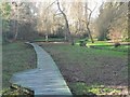
Bournemouth Gardens: walkway passing place
Along the Image, lay-bys are provided, lest anyone should fall over the edge when passing each other.
Image: © Chris Downer
Taken: 27 Jan 2008
0.07 miles
10

Bournemouth Gardens: start of raised walkway
The start of one of the raised walkways in the Gardens, taking you through what would otherwise be rather squelchy underfoot.
Image: © Chris Downer
Taken: 27 Jan 2008
0.07 miles