IMAGES TAKEN NEAR TO
Poole Road, BOURNEMOUTH, BH4 9DJ
Introduction
This page details the photographs taken nearby to Poole Road, BH4 9DJ by members of the Geograph project.
The Geograph project started in 2005 with the aim of publishing, organising and preserving representative images for every square kilometre of Great Britain, Ireland and the Isle of Man.

There are currently over 7.5m images from over14,400 individuals and you can help contribute to the project by visiting https://www.geograph.org.uk
Image Map
Images are licensed for reuse under creativecommons.org/licenses/by-sa/2.0
Notes
- Clicking on the map will re-center to the selected point.
- The higher the marker number, the further away the image location is from the centre of the postcode.
Image Listing (94 Images Found)
Images are licensed for reuse under creativecommons.org/licenses/by-sa/2.0
Image
Details
Distance
1
Westbourne: footpath A08 arrives on Poole Road
The opposite photo to Image], we look out of this public footpath as it emerges onto Poole Road from Pine Tree Glen.
See Image for the next view along the path behind us.
Image: © Chris Downer
Taken: 14 Jul 2016
0.04 miles
2
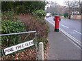
Westbourne: footpath A08 to Pine Tree Glen
Looking across the main Poole Road to the start of a short public footpath to the dead end of Pine Tree Glen, a road whose entrance for traffic is a hundred yards or so to the left.
See Image for a view out of the path towards us, with links to further pictures along the path.
Image: © Chris Downer
Taken: 14 Jul 2016
0.04 miles
3
Westbourne: footpath A08 heads for Poole Road
Looking along this public footpath from the dead end of Pine Tree Glen towards Poole Road.
See Image for its emergence onto the road ahead, and Image for the view down the path behind us.
Image: © Chris Downer
Taken: 14 Jul 2016
0.04 miles
4
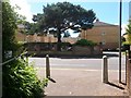
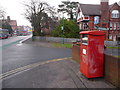
Westbourne: postbox № BH4 92, Poole Road
This Edward VII-reign postbox is emptied finally at 5:30pm on weekdays and at noon on Saturdays. To the left is a footpath the Pine Tree Glen, a road which comes out farther along Poole Road and is thus a crescent where pedestrians are concerned.
Image: © Chris Downer
Taken: 10 Jan 2009
0.05 miles
5
Westbourne: postbox № BH4 504, Poole Road
This postbox is a business box for franked mail only. It is emptied finally at 6:30pm on weekdays and is closed at weekends.
Image: © Chris Downer
Taken: 10 Jan 2009
0.05 miles
6
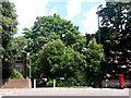
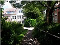
Westbourne: footpath A08 from Pine Tree Glen
Looking across the dead end of Pine Tree Glen up this short public footpath to Poole Road.
See Image] for the view down the path from just ahead, with links to further photos along the path.
Image: © Chris Downer
Taken: 14 Jul 2016
0.05 miles
7
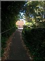
Westbourne: footpath A08 reaches Pine Tree Glen
This public footpath from Poole Road reaches its destination, the dead end of Pine Tree Glen.
See Image for the view up the path from ahead, and Image for the view up the path behind us.
Image: © Chris Downer
Taken: 14 Jul 2016
0.06 miles
8
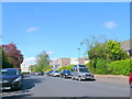
Grosvenor Road, Westbourne, Bournemouth
This area was once a haven of substantial individual houses on their own plots. These have, without exception, all been demolished and been replaced with blocks of flats such as the ones shown here in Grosvenor Road.
Image: © Nigel Mykura
Taken: 8 May 2012
0.06 miles
9
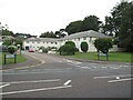
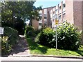
Netherhall Gardens, Westbourne, near Bournemouth
Netherhall Gardens is a residential development in Westbourne, in the suburbs of Bournemouth.
Image: © Malc McDonald
Taken: 17 Aug 2021
0.07 miles