IMAGES TAKEN NEAR TO
Seamoor Road, BOURNEMOUTH, BH4 9AA
Introduction
This page details the photographs taken nearby to Seamoor Road, BH4 9AA by members of the Geograph project.
The Geograph project started in 2005 with the aim of publishing, organising and preserving representative images for every square kilometre of Great Britain, Ireland and the Isle of Man.

There are currently over 7.5m images from over14,400 individuals and you can help contribute to the project by visiting https://www.geograph.org.uk
Image Map
Images are licensed for reuse under creativecommons.org/licenses/by-sa/2.0
Notes
- Clicking on the map will re-center to the selected point.
- The higher the marker number, the further away the image location is from the centre of the postcode.
Image Listing (115 Images Found)
Images are licensed for reuse under creativecommons.org/licenses/by-sa/2.0
Image
Details
Distance
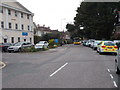
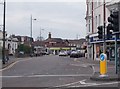
1
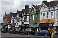
Shops in Seamoor Road
A crescent of shops in Westbourne town centre.
Image: © David Martin
Taken: 3 Mar 2024
0.01 miles
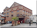
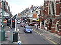
4
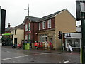
Westbourne Post Office
On Seamoor Road, with delivery office to the left.
Image: © Mike Faherty
Taken: 18 Mar 2011
0.03 miles
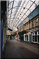
6
Industrial Building - viewed from Alum Chine Road
Image: © Betty Longbottom
Taken: 21 Apr 2016
0.03 miles
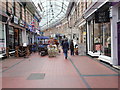
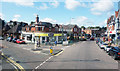
10
Poole Road, Westbourne near Bournemouth
Poole Road at Westbourne, near Bournemouth. The road becomes a one-way street at this point.
On the right is a former church, now converted into a supermarket.
Image: © Malc McDonald
Taken: 17 Aug 2012
0.04 miles