IMAGES TAKEN NEAR TO
West Cliff Road, BOURNEMOUTH, BH4 8BE
Introduction
This page details the photographs taken nearby to West Cliff Road, BH4 8BE by members of the Geograph project.
The Geograph project started in 2005 with the aim of publishing, organising and preserving representative images for every square kilometre of Great Britain, Ireland and the Isle of Man.

There are currently over 7.5m images from over14,400 individuals and you can help contribute to the project by visiting https://www.geograph.org.uk
Image Map
Images are licensed for reuse under creativecommons.org/licenses/by-sa/2.0
Notes
- Clicking on the map will re-center to the selected point.
- The higher the marker number, the further away the image location is from the centre of the postcode.
Image Listing (95 Images Found)
Images are licensed for reuse under creativecommons.org/licenses/by-sa/2.0
Image
Details
Distance
2
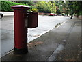
Bournemouth: postbox № BH4 120, McKinley Road
An Edward VII-reign postbox in a very desirable area.
Image: © Chris Downer
Taken: 4 Sep 2008
0.07 miles
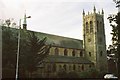
3
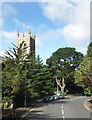
West Cliff Road, Westbourne
The tower of St Ambrose's Church behind the trees.
Image: © Des Blenkinsopp
Taken: 9 Sep 2017
0.07 miles
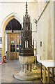
4
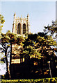
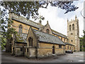
St Ambrose, Westbourne
Listed building erected in 1898.
Image: © Michael FORD
Taken: Unknown
0.09 miles
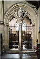
7
Westbourne: parish church of St. Ambrose
The church is currently unusable after a suspected arson attack in 2006.
Image: © Chris Downer
Taken: Unknown
0.10 miles
8
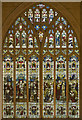
St Ambrose, Westbourne - Stained glass window
Image: © John Salmon
Taken: 20 Aug 2019
0.10 miles
10
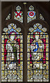
St Ambrose, Westbourne - Stained glass window
Image: © John Salmon
Taken: 20 Aug 2019
0.10 miles