IMAGES TAKEN NEAR TO
Keith Road, BOURNEMOUTH, BH3 7DS
Introduction
This page details the photographs taken nearby to Keith Road, BH3 7DS by members of the Geograph project.
The Geograph project started in 2005 with the aim of publishing, organising and preserving representative images for every square kilometre of Great Britain, Ireland and the Isle of Man.

There are currently over 7.5m images from over14,400 individuals and you can help contribute to the project by visiting https://www.geograph.org.uk
Image Map
Images are licensed for reuse under creativecommons.org/licenses/by-sa/2.0
Notes
- Clicking on the map will re-center to the selected point.
- The higher the marker number, the further away the image location is from the centre of the postcode.
Image Listing (13 Images Found)
Images are licensed for reuse under creativecommons.org/licenses/by-sa/2.0
Image
Details
Distance
1
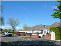
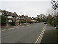
Dulsie Rd
Dulsie Rd is a long residential street consisting mainly of large bungalows such as these.
Image: © Nigel Mykura
Taken: 8 May 2012
0.11 miles
2
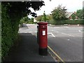
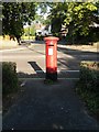
Talbot Woods: postbox № BH3 363, Carrbridge Road
As with almost all the roads in the upmarket suburb of Talbot Woods, Carrbridge Road is named after a Scottish placename. A large drop box (see below) stands immediately behind the postbox.
Image: © Chris Downer
Taken: 23 Aug 2008
0.12 miles
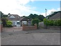
3
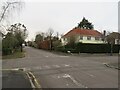
Carrbridge Road, Talbot Woods, Bournemouth
Carrbridge Road is a residential road in Talbot Woods, a suburb of Bournemouth.
Image: © Malc McDonald
Taken: 7 Feb 2022
0.13 miles
5
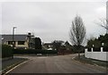
Dunkeld Road, Talbot Woods, Bournemouth
Dunkeld Road is a residential road in Talbot Woods, a suburb of Bournemouth.
Image: © Malc McDonald
Taken: 7 Feb 2022
0.20 miles
6
Talbot Woods: footpath A15 from Alyth Road
We stand in the large turning circle of Alyth Road and look along the start of this path, which, once beyond the back gardens, opens out into the Talbot Heath local nature reserve (across the border in Poole).
See Image] for a view towards us from along the path and further links to photos along its continuing route.
Image: © Chris Downer
Taken: 28 Jun 2016
0.22 miles
7
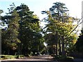
East Avenue, Bournemouth
Image seen from the junction shown in Image, running between attractive tall pines and deciduous trees as befits an avenue.
Image: © Derek Harper
Taken: 12 Oct 2009
0.22 miles
8
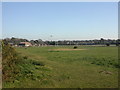
Talbot Village, Highmoor Farm
One of originally six small farms in Talbot Village Image, Highmoor is the last functioning. Stocks sheep & cattle.
Image: © Mike Faherty
Taken: 6 Jan 2009
0.22 miles
9
Talbot Woods: postbox № BH3 331, Glenferness Avenue
A George VI-reign postbox in Glenferness Avenue, with its back to the Cawdor Road junction. These two roads are typical of Talbot Woods in being named after Scottish places.
Image: © Chris Downer
Taken: 2 Jul 2008
0.22 miles
10
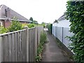
Talbot Woods: footpath A15 approaches Alyth Road
The rural feel of this public footpath, along the edge of Talbot Heath immediately behind us, is suddenly lost as we walk between two bungalows to reach the large turning circle of Alyth Road.
See Image] for the starkly contrasting next stretch of the path behind us, and Image for a view to here from the road ahead.
Image: © Chris Downer
Taken: 28 Jun 2016
0.23 miles