IMAGES TAKEN NEAR TO
Meyrick Park Crescent, BOURNEMOUTH, BH3 7AQ
Introduction
This page details the photographs taken nearby to Meyrick Park Crescent, BH3 7AQ by members of the Geograph project.
The Geograph project started in 2005 with the aim of publishing, organising and preserving representative images for every square kilometre of Great Britain, Ireland and the Isle of Man.

There are currently over 7.5m images from over14,400 individuals and you can help contribute to the project by visiting https://www.geograph.org.uk
Image Map
Images are licensed for reuse under creativecommons.org/licenses/by-sa/2.0
Notes
- Clicking on the map will re-center to the selected point.
- The higher the marker number, the further away the image location is from the centre of the postcode.
Image Listing (75 Images Found)
Images are licensed for reuse under creativecommons.org/licenses/by-sa/2.0
Image
Details
Distance
1
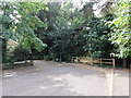
Dead end of St. Augustin's Road leading to Meyrick Park
Wood railings and gate prevents motorised access to Meyrick Park. Footpaths lead straight ahead and to the left once past the railings.
Image: © Mat Tuck
Taken: 23 Jul 2013
0.08 miles
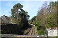
2
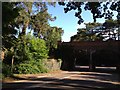
Railway bridge crossing Central Drive near Meyrick Park
Image: © Jonathan Hutchins
Taken: 9 Jun 2012
0.08 miles
4

Rainbow viewed in St. Augustin's Road
A spring storm in Bournemouth generated a double rainbow across the houses and trees, viewed in St. Augustin's Road.
Image: © Mat Tuck
Taken: 11 May 2014
0.10 miles
5
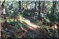
Turf Zone "CentralHike"
In Meyrick Park, Bourhemouth.
Image: © Ian S
Taken: 15 Nov 2022
0.10 miles
6
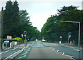
Green light in Wimborne Road
Stoke Wood Road on the right
Image: © Chris Gunns
Taken: 25 May 2009
0.12 miles
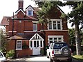
7
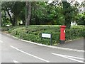
Talbot Woods: postbox № BH3 52, Wimborne Road
A fine Victorian specimen on Wimborne Road, standing at the end of what used to be the central reservation of a dual carriageway where the two sides had different names: We are looking down Meyrick Park Crescent, which use to carry traffic towards Meyrick Park, while returning traffic came up behind the bushes as we look, along Dunbar Road. However, about 10 years ago the latter was closed off and the former functions in both directions, as the road markings here suggest.
Image: © Chris Downer
Taken: 5 Jul 2008
0.13 miles
8
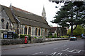
St Augustin's Church, Bournemouth
View from Wimborne Road end near the cemetery junction.
Image: © Kris
Taken: 6 May 2006
0.13 miles
9
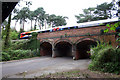
Railway Bridge near Meyrick Park
A SouthWest train from Bournemouth to Weymouth passes over the railway bridge at the entrance to Meyrick Park.
Image: © Kris
Taken: 6 May 2006
0.14 miles
10
The Bournemouth / Poole line
To the east of Cemetery junction.
Image: © David Lally
Taken: 10 Apr 2016
0.14 miles