IMAGES TAKEN NEAR TO
Station Road, VERWOOD, BH31 7PY
Introduction
This page details the photographs taken nearby to Station Road, BH31 7PY by members of the Geograph project.
The Geograph project started in 2005 with the aim of publishing, organising and preserving representative images for every square kilometre of Great Britain, Ireland and the Isle of Man.

There are currently over 7.5m images from over14,400 individuals and you can help contribute to the project by visiting https://www.geograph.org.uk
Image Map
Images are licensed for reuse under creativecommons.org/licenses/by-sa/2.0
Notes
- Clicking on the map will re-center to the selected point.
- The higher the marker number, the further away the image location is from the centre of the postcode.
Image Listing (40 Images Found)
Images are licensed for reuse under creativecommons.org/licenses/by-sa/2.0
Image
Details
Distance
1
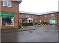
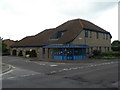
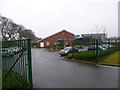
Verwood Surgery
On Station Road; the site includes pharmacist, physiotherapist and veterinary practice: http://www.verwoodsurgery.co.uk/
Image: © Mike Faherty
Taken: 7 Mar 2013
0.01 miles
2
Verwood: clinic and vets
Verwood Clinic occupies the centre section of this modern, symmetrical building; the vets is to the left and, out of picture, a pharmacy is to the right.
Image: © Chris Downer
Taken: 7 Sep 2008
0.01 miles
4
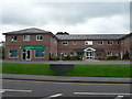
Verwood Police Station
On Station Road, at the corner of Jenner Close: http://www.dorset.police.uk/default.aspx?page=2505#verwood
Image: © Mike Faherty
Taken: 7 Mar 2013
0.04 miles
5
Verwood: police station
A modern building in this bit of town that has seen much recent redevelopment.
Image: © Chris Downer
Taken: 7 Sep 2008
0.04 miles
6
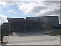
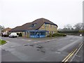
Verwood's new Community Centre, 'The Hub'
Front view of The Hub taken from the approach from the carpark.
Image: © Sandra Ground
Taken: 10 Mar 2007
0.06 miles
7
Verwood: The Hub
A new community centre for the town.
Image: © Chris Downer
Taken: 7 Sep 2008
0.06 miles
8
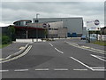
The Verwood Community Centre - 'The Hub'
Rear of Verwood's new community centre seen from the distributor road
Image: © Sandra Ground
Taken: 10 Mar 2007
0.06 miles
9
Verwood Day Centre
On Jenner Close, operated by Dorset County Council: http://www.dorsetforyou.com/355935?navid=355966
Image: © Mike Faherty
Taken: 7 Mar 2013
0.07 miles
10
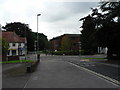
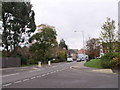
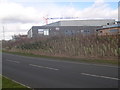
Verwood: former main crossroads
This used to be a busy crossroads, where the four main roads into the town met. Now, though, the main routes north and south have been diverted onto new roads, as illustrated on the map, and the centre of town is quieter, traffic-wise, as a result.
North (ahead), we have the now closed Edmondsham Road, leading to the village of that name; east, we have Ringwood Road, the B3081 towards Ringwood; south, Manor Road leads towards West Moors and, eventually, Ferndown and Bournemouth; and west, Station Road takes us past the old railway station to Cranborne, Shaftesbury and Shepton Mallet.
Image: © Chris Downer
Taken: 7 Sep 2008
0.07 miles