IMAGES TAKEN NEAR TO
Ringwood Road, VERWOOD, BH31 7AR
Introduction
This page details the photographs taken nearby to Ringwood Road, BH31 7AR by members of the Geograph project.
The Geograph project started in 2005 with the aim of publishing, organising and preserving representative images for every square kilometre of Great Britain, Ireland and the Isle of Man.

There are currently over 7.5m images from over14,400 individuals and you can help contribute to the project by visiting https://www.geograph.org.uk
Image Map (Loading...)


Getting Data...Please wait
Leaflet Map data © OpenStreetMap
Images are licensed for reuse under creativecommons.org/licenses/by-sa/2.0
Notes
- Clicking on the map will re-center to the selected point.
- The higher the marker number, the further away the image location is from the centre of the postcode.
Image Listing (14 Images Found)
Images are licensed for reuse under creativecommons.org/licenses/by-sa/2.0
Image
Details
Distance
1
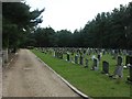
Verwood Cemetery
Off Ringwood Road, surrounded by strips of coniferous woodland on all sides, no doubt as a shield, and also allowing for future expansion. The earliest graves seem to date from the 1960s.
Image: © Mike Faherty
Taken: 24 Jul 2009
0.10 miles
2
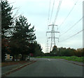
Black Moor Road, Verwood
Near the Ebblake Trading Estate, electricity pylons dominate the skyline.
Image: © Peter Kazmierczak
Taken: 6 Nov 2011
0.13 miles
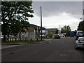
3
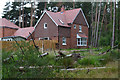
Modern housing development on the edge of Ringwood Forest
Image: © David Martin
Taken: 15 Jul 2020
0.17 miles
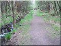
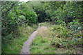
4
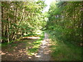
Ebblake, path
Leading to Ringwood Forest from Ringwood Road. The ditch to the left forms the Dorset/Hants boundary (Hants on this side).
Image: © Mike Faherty
Taken: 21 Jul 2013
0.18 miles
6
Verwood, Ebblake Industrial Estate
Light industrial units on Black Moor Road.
Image: © Mike Faherty
Taken: 24 Jul 2009
0.19 miles
7
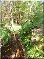
Ringwood Forest, ditch
Forming the county boundary between Dorset (left) and Hampshire (right).
Image: © Mike Faherty
Taken: 21 Jul 2013
0.20 miles
8
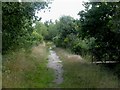
Verwood, boundary
The ditch under the footbridge to the right forms a county boundary; to the left of it, Hampshire (New Forest), to the right, East Dorset.
Image: © Mike Faherty
Taken: 24 Jul 2009
0.20 miles
10
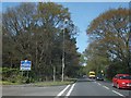
Welcome to Verwood
The edge of Verwood, with trees lining the road on the left
Image: © David Smith
Taken: 3 May 2014
0.21 miles