IMAGES TAKEN NEAR TO
Bugdens Lane, VERWOOD, BH31 6EY
Introduction
This page details the photographs taken nearby to Bugdens Lane, BH31 6EY by members of the Geograph project.
The Geograph project started in 2005 with the aim of publishing, organising and preserving representative images for every square kilometre of Great Britain, Ireland and the Isle of Man.

There are currently over 7.5m images from over14,400 individuals and you can help contribute to the project by visiting https://www.geograph.org.uk
Image Map (Loading...)


Getting Data...Please wait
Leaflet Map data © OpenStreetMap
Images are licensed for reuse under creativecommons.org/licenses/by-sa/2.0
Notes
- Clicking on the map will re-center to the selected point.
- The higher the marker number, the further away the image location is from the centre of the postcode.
Image Listing (10 Images Found)
Images are licensed for reuse under creativecommons.org/licenses/by-sa/2.0
Image
Details
Distance
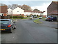
1
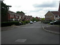
Verwood, Hainault Drive
One of many roads with modern housing to the East of Verwood.
Image: © Mike Faherty
Taken: 20 Jun 2009
0.08 miles
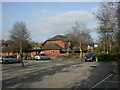
2

Verwood Leisure Centre
Stark building on Chiltern Drive; see http://www.verwoodleisure.co.uk/
Image: © Mike Faherty
Taken: 22 Mar 2009
0.08 miles
3
Verwood, The Swans
Modern Marston's pub on Pennine Way; internally, open-plan, curving back bar, with eating area to left, drinking to right; pool, games machines, TV. Cask ale on offer at my visit: Ringwood Best. For some customer comments (which seem to be limited), see http://www.beerintheevening.com/pubs/s/74/7493/Three_Swans/Verwood
Image: © Mike Faherty
Taken: 3 Mar 2011
0.10 miles
4
Verwood, postbox
Image: © Mike Faherty
Taken: 22 Mar 2009
0.11 miles
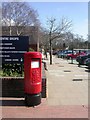
5
Verwood: postbox № BH31 208, Pennine Way
This postbox is on the concourse of the main shopping centre which includes Morrison's supermarket, behind camera, and Verwood Leisure Centre, whose end we see on the left. The postbox is emptied finally at 5:30pm on weekdays and at 8am on Saturdays.
Image: © Chris Downer
Taken: 29 Mar 2009
0.11 miles
6
Verwood residential area
Verwood is one of the fastest-growing places in east Dorset.
Image: © Stuart Buchan
Taken: 22 Dec 2005
0.18 miles
7
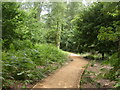
Verwood, Bugden's Copse
East of Verwood village, West of modern suburban housing, an oasis of tranquillity. According to an information board, the last vestige of Fayre Wood, from which Verwood derives its name. Once the source of wood for furniture and fuel, coppiced; now sympathetically managed. Local Nature Reserve & SSSI. http://195.49.180.81/index.jsp?articleid=330160
Image: © Mike Faherty
Taken: 20 Jun 2009
0.20 miles
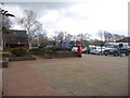
8
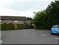
Verwood, painter painted?
In the car park of Image To the right is the beginning of a short footpath to Chiltern Drive.
Image: © Mike Faherty
Taken: 1 Jun 2011
0.20 miles
9
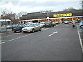
Morrisons, Verwood, Dorset
Until recently this was a Safeway supermarket. Close by is the leisure centre.
Image: © Stuart Buchan
Taken: 22 Dec 2005
0.23 miles
10
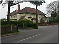
Verwood, The Monmouth Ash
Hall & Woodhouse-owned pub in Manor Road. Internally, L-shaped bar, drinking & eating areas to front & right. Cask ales on offer at my visit: Badger, Hopping Hare, Tanglefoot. For some customer reviews, see http://www.beerintheevening.com/pubs/s/12/12167/Monmouth_Ash/Verwood
Image: © Mike Faherty
Taken: 18 Apr 2009
0.24 miles