
IMAGES TAKEN NEAR TO
Wychwood Close, BOURNEMOUTH, BH2 6JF
Introduction
This page details the photographs taken nearby to Wychwood Close, BH2 6JF by members of the Geograph project.
The Geograph project started in 2005 with the aim of publishing, organising and preserving representative images for every square kilometre of Great Britain, Ireland and the Isle of Man.

There are currently over 7.5m images from over14,400 individuals and you can help contribute to the project by visiting https://www.geograph.org.uk
Image Map
Images are licensed for reuse under creativecommons.org/licenses/by-sa/2.0
Notes
- Clicking on the map will re-center to the selected point.
- The higher the marker number, the further away the image location is from the centre of the postcode.
Image Listing (128 Images Found)
Images are licensed for reuse under creativecommons.org/licenses/by-sa/2.0
Image
Details
Distance
1

Bournemouth: wintry scene in Central Drive
Looking along Central Drive, the road through Meyrick Park, at least before being closed to through traffic a few years ago. Bournemouth's heaviest snow for 17 years fell overnight.
Image: © Chris Downer
Taken: 2 Dec 2010
0.03 miles
2
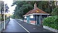
Small utility building in Meyrick Park
From an nearby info board I got the impression this may be a Golf shop in the summer. But the golf course is not on a direct route from here?
Image: © David Lally
Taken: 1 Mar 2015
0.04 miles
3

Bournemouth: Coppice Corner
A small coppice in Meyrick Park, on a small plot reclaimed from a long-disused putting green.
Image: © Chris Downer
Taken: 26 Feb 2010
0.05 miles
4

Bournemouth: nature notes at Coppice Corner
An information board, seemingly aimed at children, referring to hazel catkins. Other boards deal with jays, wrens and hazel leaves.
Image: © Chris Downer
Taken: 26 Feb 2010
0.05 miles
5

Bournemouth: path through Coppice Corner
The path that goes round Image
Image: © Chris Downer
Taken: 26 Feb 2010
0.05 miles
6
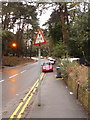
Bournemouth: redundant height warning sign in Meyrick Park
Now that the Central Drive through Meyrick Park has been permanently closed to traffic (see Image), this warning sign is redundant, since the railway bridge to which it refers is no longer accessible from here.
Image: © Chris Downer
Taken: 25 Mar 2010
0.05 miles
7
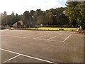
Bournemouth: Meyrick Park car park
When the main road through the Park was closed permanently to through traffic, it took with it the roadside parking which was intended for park users but mostly used by commuters. Now, this car park has been created on the site of some tennis courts (there are still a couple remaining), dedicated for park users. Given that it is virtually empty, I presume this is policed quite rigorously.
The Image is in the background.
Image: © Chris Downer
Taken: 26 Feb 2010
0.05 miles
8

Bournemouth: Meyrick Park bowls pavilion
A view of the north side of Image, which as you can see has a bowling green on both sides of the pavilion.
Image: © Chris Downer
Taken: 26 Feb 2010
0.06 miles
9

Bournemouth: bowls at Meyrick Park
The bowling green and pavilion at Meyrick Park, open to the public for teas and snacks when games are in progress.
Image: © Chris Downer
Taken: 26 Feb 2010
0.06 miles
10

Bournemouth: Meyrick Park bowling club in snow
Little chance for a game today, as Bournemouth's heaviest snow for 17 years fell overnight.
Image: © Chris Downer
Taken: 2 Dec 2010
0.06 miles