IMAGES TAKEN NEAR TO
Suffolk Road, BOURNEMOUTH, BH2 6AT
Introduction
This page details the photographs taken nearby to Suffolk Road, BH2 6AT by members of the Geograph project.
The Geograph project started in 2005 with the aim of publishing, organising and preserving representative images for every square kilometre of Great Britain, Ireland and the Isle of Man.

There are currently over 7.5m images from over14,400 individuals and you can help contribute to the project by visiting https://www.geograph.org.uk
Image Map
Images are licensed for reuse under creativecommons.org/licenses/by-sa/2.0
Notes
- Clicking on the map will re-center to the selected point.
- The higher the marker number, the further away the image location is from the centre of the postcode.
Image Listing (315 Images Found)
Images are licensed for reuse under creativecommons.org/licenses/by-sa/2.0
Image
Details
Distance
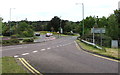
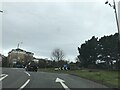
1
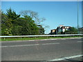
Bournemouth : Cambridge Road B3066
A road heading off from Wessex Way.
Image: © Lewis Clarke
Taken: 27 Mar 2018
0.03 miles
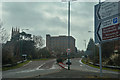
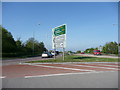
2
Directions sign facing the B3066 in Bournemouth
On the approach to Bournemouth West Roundabout.
Turn left ahead for Westbourne, Canford Cliffs, Sandbanks.
Turn right ahead for Charminster, Winton, Boscombe, Lyndhurst.
Image: © Jaggery
Taken: 25 May 2016
0.03 miles
3
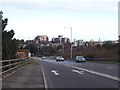
Wessex Way
The roundabout at the junction of Wessex Way and Cambridge Road. The financial office blocks of Bournemouth are visible on the skyline to the east.
Image: © Steve Rigg
Taken: 1 Jan 2006
0.03 miles
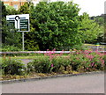
4
Northern end of the B3066, Bournemouth
About 3km long, the B3066 is entirely within Bournemouth.
Its northern end ahead is at the A338 junction at the Bournemouth West Roundabout.
Image: © Jaggery
Taken: 25 May 2016
0.04 miles
5
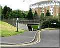
Subway under the B3066, Bournemouth
Looking west from the corner of Suffolk Road and Cambridge Road.
Image: © Jaggery
Taken: 25 May 2016
0.04 miles
6
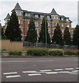
East side of Norwich Avenue West flats, Bournemouth
Viewed across the B3066 Cambridge Road.
Image: © Jaggery
Taken: 25 May 2016
0.05 miles
9
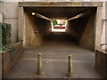
Bournemouth: Suffolk Road South subway
Looking south from the dead-end of Suffolk Road South, through the subway to Suffolk Road. As you might gather, this really ought to be called Suffolk Road North!
For more discussion on that, see Image
The town-centre by-pass runs above the subway.
Image: © Chris Downer
Taken: 11 Feb 2010
0.06 miles