IMAGES TAKEN NEAR TO
Suffolk Road, BOURNEMOUTH, BH2 5SX
Introduction
This page details the photographs taken nearby to Suffolk Road, BH2 5SX by members of the Geograph project.
The Geograph project started in 2005 with the aim of publishing, organising and preserving representative images for every square kilometre of Great Britain, Ireland and the Isle of Man.

There are currently over 7.5m images from over14,400 individuals and you can help contribute to the project by visiting https://www.geograph.org.uk
Image Map
Images are licensed for reuse under creativecommons.org/licenses/by-sa/2.0
Notes
- Clicking on the map will re-center to the selected point.
- The higher the marker number, the further away the image location is from the centre of the postcode.
Image Listing (574 Images Found)
Images are licensed for reuse under creativecommons.org/licenses/by-sa/2.0
Image
Details
Distance
1
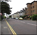
Suffolk Road, Bournemouth
From the Cambridge Road end.
Image: © Jaggery
Taken: 25 May 2016
0.02 miles
2
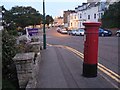
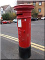
Bournemouth: postbox № BH2 109, Suffolk Road
A short time before dusk, we look east along Suffolk Road, past this Edward VII-reign postbox.
Image: © Chris Downer
Taken: 11 Sep 2008
0.03 miles
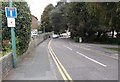
4
Suffolk Road - viewed from Norwich Avenue
Image: © Betty Longbottom
Taken: 21 Apr 2016
0.03 miles
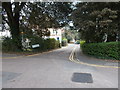
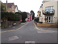
5
Edward VII Post Box - Suffolk Road
Image: © Betty Longbottom
Taken: 21 Apr 2016
0.04 miles
9
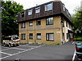
Bourneside Manor, Cambridge Road, Bournemouth
Flats at 11 Cambridge Road.
Image: © Jaggery
Taken: 25 May 2016
0.05 miles
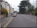
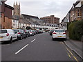
10
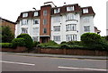
Riviera Court, Suffolk Road, Bournemouth
Four-storey block of flats.
Image: © Jaggery
Taken: 25 May 2016
0.06 miles