IMAGES TAKEN NEAR TO
St. Michaels Place, BOURNEMOUTH, BH2 5EE
Introduction
This page details the photographs taken nearby to St. Michaels Place, BH2 5EE by members of the Geograph project.
The Geograph project started in 2005 with the aim of publishing, organising and preserving representative images for every square kilometre of Great Britain, Ireland and the Isle of Man.

There are currently over 7.5m images from over14,400 individuals and you can help contribute to the project by visiting https://www.geograph.org.uk
Image Map
Images are licensed for reuse under creativecommons.org/licenses/by-sa/2.0
Notes
- Clicking on the map will re-center to the selected point.
- The higher the marker number, the further away the image location is from the centre of the postcode.
Image Listing (689 Images Found)
Images are licensed for reuse under creativecommons.org/licenses/by-sa/2.0
Image
Details
Distance
1
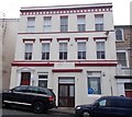
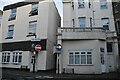
Bournemouth West Conservative Club - St Michael's Road
Image: © Betty Longbottom
Taken: 18 Apr 2016
0.01 miles
2
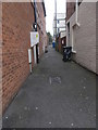
St Michael's Lane - St Michael's Road
Image: © Betty Longbottom
Taken: 18 Apr 2016
0.02 miles
3
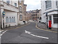
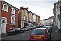
St Michael's Road, Bournemouth
One-way street ascending from Commercial Road.
Image: © Jaggery
Taken: 25 May 2016
0.02 miles
5
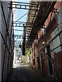
Doing up Mannington Place
Work at all levels.
Image: © Neil Owen
Taken: 22 Jun 2022
0.02 miles
7
Bournemouth: uprooted bollard in West Hill Place
West Hill Place is a funny little road which surrounds three sides of the West Hill public car park, providing rear access to the properties hereabouts. Through passage in a vehicle onto Mannington Place, just behind us, is not theoretically possible because of the bollards just ahead of us - however, the central one is missing and is stood up to the left, so one could drive through if desired.
The double-yellow lines also depict the intended road blockage, and previous lines are also visible showing that the turning area on the farther carriageway has been widened a little.
Image: © Chris Downer
Taken: 24 Jan 2017
0.02 miles
8
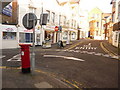
Bournemouth: postbox № BH2 66, St. Michael?s Road
This Victorian postbox stands at the northern turning of Purbeck Road. Purbeck and St. Michael's Roads form a loop in the otherwise straight latter, bizarrely being one-way street in the anticlockwise direction. I'm sure it used to be clockwise.
Image: © Chris Downer
Taken: 4 Jan 2010
0.02 miles
9
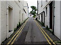
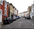
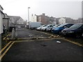
No parking in Mannington Place, Bournemouth
On the south side of Commercial Road. Double yellow lines on both sides indicate no parking at any time.
Image: © Jaggery
Taken: 25 May 2016
0.03 miles