IMAGES TAKEN NEAR TO
Farm Lane South, NEW MILTON, BH25 7BR
Introduction
This page details the photographs taken nearby to Farm Lane South, BH25 7BR by members of the Geograph project.
The Geograph project started in 2005 with the aim of publishing, organising and preserving representative images for every square kilometre of Great Britain, Ireland and the Isle of Man.

There are currently over 7.5m images from over14,400 individuals and you can help contribute to the project by visiting https://www.geograph.org.uk
Image Map
Images are licensed for reuse under creativecommons.org/licenses/by-sa/2.0
Notes
- Clicking on the map will re-center to the selected point.
- The higher the marker number, the further away the image location is from the centre of the postcode.
Image Listing (11 Images Found)
Images are licensed for reuse under creativecommons.org/licenses/by-sa/2.0
Image
Details
Distance
1

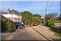
Farm Lane South
This is a typical residential road at Barton on Sea, with bungalows and medium size houses.
Image: © mike smith
Taken: 5 Dec 2011
0.02 miles
2

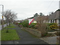
Barton Croft
This is a traditional residential road of medium-priced houses.
Image: © mike smith
Taken: 5 Dec 2011
0.05 miles
3
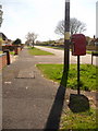
New Milton: postbox № BH25 184, Barton Croft
Looking along Barton Croft, a typical residential road in New Milton and Barton. The postbox is emptied at 4pm on weekdays and at 11:45am on Saturdays.
Image: © Chris Downer
Taken: 13 Apr 2009
0.07 miles
4
Barton on Sea, Barton Croft
Barton, in common with many other locations on the south coast, has extensive tracts of popular bungalows. The one here behind the "For Sale" sign is probably to be found at http://www.pettengells.co.uk/propertyDetails.php?pid=115683
Image: © Mike Faherty
Taken: 20 Dec 2008
0.08 miles
5

Stream alongside Mitchell Close
This stream flows for only just over a kilometre through residential Barton on Sea, but continues for a similar distance over open land, entering the sea at Beckton Bunny.
Image: © mike smith
Taken: 5 Dec 2011
0.18 miles
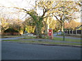
6
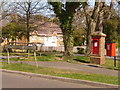
New Milton: postbox № BH25 88, Barton Court Avenue
This postbox shares the grass triangle, on the corner of Barton Court Avenue and Highlands Road, with a dog-waste disposal bin.
It is important that these two red receptacles are not confused – it could have disastrous consequences either for your own letters or for other people's, depending on which you are supposed to be using.
The postbox – which I guess I should now clarify is the one on the left – is emptied at 5pm on weekdays and at 11:45 on Saturday mornings. The dog-waste bin does not advertise its collection times!
Image: © Chris Downer
Taken: 13 Apr 2009
0.20 miles
7
Farm Lane North
This road is unmade, being gravel only, but generally free of pot holes. There are some large houses on the lane, which is a cul-de-sac, but which has a footpath at the end giving access to the main Lymington Road.
Image: © mike smith
Taken: 5 Dec 2011
0.22 miles
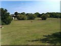
8
Barton on Sea
Road junction in a residential area of Barton on Sea.
Image: © Stuart Buchan
Taken: 21 Jan 2006
0.22 miles
10
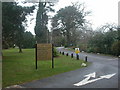
Barton on Sea, Durlston Court School
No local primary school, this! Why it should be named after a location 26km away (as the crow flies), I didn't know, until an answer came back: John Teather reports that the school was originally at Durlston Head, but had to be relocated because of WW2 damage; after the war, it was re-established here. http://www.durlstoncourt.co.uk/
Image: © Mike Faherty
Taken: 20 Dec 2008
0.24 miles