IMAGES TAKEN NEAR TO
Linhorns Lane, NEW MILTON, BH25 5DQ
Introduction
This page details the photographs taken nearby to Linhorns Lane, BH25 5DQ by members of the Geograph project.
The Geograph project started in 2005 with the aim of publishing, organising and preserving representative images for every square kilometre of Great Britain, Ireland and the Isle of Man.

There are currently over 7.5m images from over14,400 individuals and you can help contribute to the project by visiting https://www.geograph.org.uk
Image Map
Images are licensed for reuse under creativecommons.org/licenses/by-sa/2.0
Notes
- Clicking on the map will re-center to the selected point.
- The higher the marker number, the further away the image location is from the centre of the postcode.
Image Listing (12 Images Found)
Images are licensed for reuse under creativecommons.org/licenses/by-sa/2.0
Image
Details
Distance
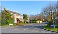
1
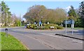
Welcome to Bashley
Sway Road viewed from the roundabout.
Image: © Anthony Vosper
Taken: 10 Aug 2012
0.05 miles
2
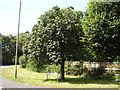
Horse Chestnut tree, Bashley Road
It looks like there will be a good crop this year.
But does anyone still play conkers?
Image: © Anthony Vosper
Taken: 10 Aug 2012
0.07 miles
3
Bashley Crossroads
This was a traditional crossroads until about 30 years ago, when the roundabout was constructed.
Image: © mike smith
Taken: 3 Apr 2012
0.07 miles
4
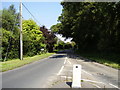
Fernhill Lane
It may have been a lane once, but now this is a busy road leading north from New Milton towards the A35.
Image: © mike smith
Taken: 3 Apr 2012
0.09 miles
5
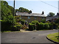
Cull lane cottages
These cottages originally stood on the crossroads with Mark's Lane and Sway Road.
Access has now been limited to foot traffic only.
Image: © Anthony Vosper
Taken: 10 Aug 2012
0.13 miles
6
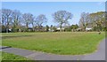
Amenity Green
This green is a welcome feature in the middle of a massive residential development which took place in the area during the 1970s and 1980s.
Image: © mike smith
Taken: 3 Apr 2012
0.13 miles
7
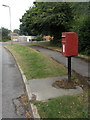
New Milton: postbox № BH25 20, Hollandswood Drive
An ordinary Elizabeth II-reign postbox on a metal pole, near the western end of Hollandswood Drive (as it is spelt on signage, although most maps give it as three words).
Image: © Chris Downer
Taken: 28 Jul 2013
0.14 miles
8
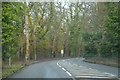
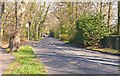
New Milton : Fernhill Lane B3058
Looking along Fernhill Lane as it heads out of New Milton.
Image: © Lewis Clarke
Taken: 28 Mar 2018
0.14 miles
9
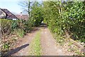
Dirt Track at Bashley
According to the sign near here, the track leads to Spa Cottage.
Image: © mike smith
Taken: 3 Apr 2012
0.15 miles
10
Deerleap Way
This is part of the massive residential development which took place in the area during the 1970s and 1980s.
Image: © mike smith
Taken: 3 Apr 2012
0.15 miles