IMAGES TAKEN NEAR TO
Ringwood Trading Estate, Castleman Way, RINGWOOD, BH24 3BA
Introduction
This page details the photographs taken nearby to Ringwood Trading Estate, Castleman Way, BH24 3BA by members of the Geograph project.
The Geograph project started in 2005 with the aim of publishing, organising and preserving representative images for every square kilometre of Great Britain, Ireland and the Isle of Man.

There are currently over 7.5m images from over14,400 individuals and you can help contribute to the project by visiting https://www.geograph.org.uk
Image Map (Loading...)


Getting Data...Please wait
Leaflet Map data © OpenStreetMap
Images are licensed for reuse under creativecommons.org/licenses/by-sa/2.0
Notes
- Clicking on the map will re-center to the selected point.
- The higher the marker number, the further away the image location is from the centre of the postcode.
Image Listing (123 Images Found)
Images are licensed for reuse under creativecommons.org/licenses/by-sa/2.0
Image
Details
Distance
1
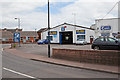
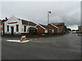
A. M. Autos
On corner of Christchurch Road and Castleman Way.
Image: © Peter Facey
Taken: 12 Jun 2010
0.03 miles
2
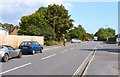
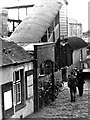
Castleman Way, Ringwood
This road has been built on the trackbed of a railway which had opened in 1847 but was closed in 1966. It was promoted by Charles Castleman, a Wimborne solicitor, and the winding route from Brockenhurst to Poole Junction soon became known as Castleman’s Corkscrew. The road name commemorates Charles Castleman.
Image: © mike smith
Taken: 12 Sep 2014
0.04 miles
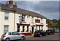
4
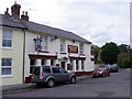
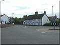
The Railway Hotel, Ringwood
The hotel is situated near the location of the former Railway Station/junction.
Image: © Maigheach-gheal
Taken: 7 Sep 2011
0.04 miles
5
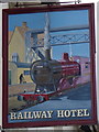
Sign for the Railway Hotel
For a wider view of the hotel Image
Image: © Maigheach-gheal
Taken: 7 Sep 2011
0.04 miles
6
Ringwood railway station in 1944
Taken by my father from an upstairs window of Station House in the months leading up to D-Day in 1944. In a few months time this little country station would be transformed with the arrival on specially adapted trains of the first American casualties from the codenamed beaches of Omaha and Utah.
Ringwood lost its railway in 1967 when the line from Brockenhurst was axed under Beeching, and the station and its associated buildings including Station House was demolished. The whole area is now a large industrial estate.
Image: © Ronald Searle
Taken: Unknown
0.04 miles
7
Ringwood, thatched cottage
No.130, Christchurch Road, at junction with Castleman Way. Presumably the right hand cottage was also originally thatched.
Image: © Mike Faherty
Taken: 3 Aug 2009
0.04 miles
8
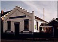
Salvation Army, Ringwood
The Salvation Army church in Ringwood, photographed on a damp and gloomy day in August 2021.
Image: © Malc McDonald
Taken: 20 Aug 2021
0.04 miles
9
The Railway Hotel, Ringwood
This thriving pub/restaurant used to be opposite Ringwood Station. The railway closed in the 1960s and the trackbed is now a road. The station buildings have been demolished to make way for light industrial units.
Image: © mike smith
Taken: 12 Sep 2014
0.04 miles
10
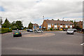
Mini-roundabout on Christchurch Road
With Castleman Way at right and Bickerley Road at left. There used to be a railway running across here.
Image: © Peter Facey
Taken: 12 Jun 2010
0.05 miles