IMAGES TAKEN NEAR TO
Woodlands Way, RINGWOOD, BH24 2LL
Introduction
This page details the photographs taken nearby to Woodlands Way, BH24 2LL by members of the Geograph project.
The Geograph project started in 2005 with the aim of publishing, organising and preserving representative images for every square kilometre of Great Britain, Ireland and the Isle of Man.

There are currently over 7.5m images from over14,400 individuals and you can help contribute to the project by visiting https://www.geograph.org.uk
Image Map
Images are licensed for reuse under creativecommons.org/licenses/by-sa/2.0
Notes
- Clicking on the map will re-center to the selected point.
- The higher the marker number, the further away the image location is from the centre of the postcode.
Image Listing (13 Images Found)
Images are licensed for reuse under creativecommons.org/licenses/by-sa/2.0
Image
Details
Distance
1
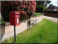
St. Ives: postbox № BH24 76, Sandy Lane
This small postbox has had a period of absence (it was certainly absent when Google Maps photographed the area in June 2009) but is back in service on the junction of Woodlands Way with Sandy Lane, one of the main roads through the village.
Image: © Chris Downer
Taken: 18 May 2013
0.05 miles
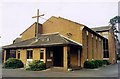
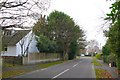
2
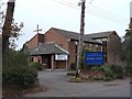
St. Leonards & St. Ives: parish church of All Saints
The parish of St. Leonards & St. Ives is a modern parish in east Dorset. While the name St. Leonards derives from the saint of that name, St. Ives, which merges with St. Leonards, is named from the plant ivy – the 'Saint' probably having been added because St. Leonards was adjoining.
Image: © Chris Downer
Taken: 24 Nov 2007
0.14 miles
4
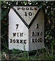
Old Milepost by Ringwood Road, St Ives
Cast iron post by the UC road, in parish of St Leonards and St Ives (East Dorset District), St Ives, East of Church, opposite No. 140, small red brick bungalow, opposite lay-by outside bungalow, on South side of the old Ringwood Road. Ringwood cast iron post, erected by the Ringwood, Longham & Leigh turnpike trust in the 19th century.
Inscription reads:-
: 7 / WIM- / BORNE : : POOLE / 10 : : 2 / RING- / WOOD :
Milestone Society National ID: HA_WBPO07
Image: © J Tybjerg
Taken: 15 Jul 2002
0.17 miles
5
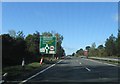
Approaching Woolsbridge roundabout, A31
Image: © Alex McGregor
Taken: 21 Apr 2012
0.18 miles
6
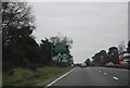
Approaching the Woolsbridge Roundabout, A31
Image: © N Chadwick
Taken: 27 Dec 2011
0.18 miles
7
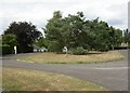
St Leonards, green
On Lions Wood. Properties around the green are larger, individually designed bungalows.
Image: © Mike Faherty
Taken: 8 Aug 2010
0.19 miles
8
A31 roundabout, St. Leonards, Dorset
This is the access road to Avon Heath Country Park.
Image: © Stuart Buchan
Taken: 27 Nov 2005
0.21 miles
9
Lions Lane Ashley Heath
Looking SW along the lane from close to the junction with Woolsbridge Rd.
Image: © Nigel Mykura
Taken: 26 Nov 2008
0.21 miles
10

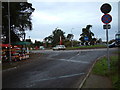
Westbound A31 nearing Woolsbridge roundabout
Local roads to left and right, with a residential area to the right.
Image: © Robin Webster
Taken: 30 Oct 2012
0.22 miles