1
St. Ives: postbox № BH24 76, Sandy Lane
This small postbox has had a period of absence (it was certainly absent when Google Maps photographed the area in June 2009) but is back in service on the junction of Woodlands Way with Sandy Lane, one of the main roads through the village.
Image: © Chris Downer
Taken: 18 May 2013
0.03 miles
2
Lions Lane Ashley Heath
Looking SW along the lane from close to the junction with Woolsbridge Rd.
Image: © Nigel Mykura
Taken: 26 Nov 2008
0.18 miles
3
St Leonards, green
On Lions Wood. Properties around the green are larger, individually designed bungalows.
Image: © Mike Faherty
Taken: 8 Aug 2010
0.19 miles
4
St. Leonards & St. Ives: parish church of All Saints
The parish of St. Leonards & St. Ives is a modern parish in east Dorset. While the name St. Leonards derives from the saint of that name, St. Ives, which merges with St. Leonards, is named from the plant ivy – the 'Saint' probably having been added because St. Leonards was adjoining.
Image: © Chris Downer
Taken: 24 Nov 2007
0.20 miles
5
All Saints, St Leonards
Built in 1927.
Image: © Michael FORD
Taken: Unknown
0.20 miles
6
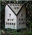
Old Milepost by Ringwood Road, St Ives
Cast iron post by the UC road, in parish of St Leonards and St Ives (East Dorset District), St Ives, East of Church, opposite No. 140, small red brick bungalow, opposite lay-by outside bungalow, on South side of the old Ringwood Road. Ringwood cast iron post, erected by the Ringwood, Longham & Leigh turnpike trust in the 19th century.
Inscription reads:-
: 7 / WIM- / BORNE : : POOLE / 10 : : 2 / RING- / WOOD :
Milestone Society National ID: HA_WBPO07
Image: © J Tybjerg
Taken: 15 Jul 2002
0.23 miles
7
Residential Road, Ringwood
This is the view along Ashley drive South in the very SE corner of the square near its junction with Sandy Lane.
Image: © Nigel Mykura
Taken: 26 Nov 2008
0.23 miles
8
St Leonards, playground
With older and younger sections, on
Image
Image: © Mike Faherty
Taken: 8 Aug 2010
0.24 miles
9
Approaching Woolsbridge roundabout, A31
Image: © Alex McGregor
Taken: 21 Apr 2012
0.24 miles
10
Ashley Heath: postbox № BH24 57, Ashley Drive South
This small postbox is in an upmarket, rhododendrony location, and is emptied at 3 o'clock on weekday afternoons and at nine on Saturday mornings.
Image: © Chris Downer
Taken: 8 Jun 2009
0.24 miles


