
IMAGES TAKEN NEAR TO
Meadow Close, RINGWOOD, BH24 1RX
Introduction
This page details the photographs taken nearby to Meadow Close, BH24 1RX by members of the Geograph project.
The Geograph project started in 2005 with the aim of publishing, organising and preserving representative images for every square kilometre of Great Britain, Ireland and the Isle of Man.

There are currently over 7.5m images from over14,400 individuals and you can help contribute to the project by visiting https://www.geograph.org.uk
Image Map
Images are licensed for reuse under creativecommons.org/licenses/by-sa/2.0
Notes
- Clicking on the map will re-center to the selected point.
- The higher the marker number, the further away the image location is from the centre of the postcode.
Image Listing (7 Images Found)
Images are licensed for reuse under creativecommons.org/licenses/by-sa/2.0
Image
Details
Distance
1
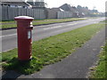
Ringwood: postbox № BH24 39, Hampton Drive
Looking along Hampton Drive from close to its junction with Seymour Road. The Elizabeth II-reign postbox is emptied finally at 5:15pm on weekdays and at noon on Saturdays.
Image: © Chris Downer
Taken: 20 Mar 2011
0.10 miles
4
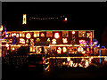
Christmas lights, Fairlie Park, Ringwood
Every year a number of residents in this part of Ringwood decorate their houses with an incredible array of festive lights. Money raised from visitors and passers by is donated to various local charities.
Image: © Jim Champion
Taken: 9 Dec 2005
0.21 miles
5
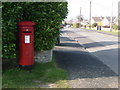
Ringwood: postbox № BH24 15, Southampton Road
This Elizabeth II-reign postbox stands on the corner of Fieldway, along which we are looking, and is emptied finally at 4pm on weekdays and at noon on Saturdays.
Image: © Chris Downer
Taken: 20 Mar 2011
0.21 miles
6
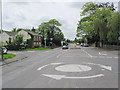
Junction of Southampton Road and Broadshard Lane, Ringwood
This was how the A31 entered Ringwood before the Ringwood bypass was built. Broadshard Lane is on the right. Lilac Close on the left with the Hunters Lodge public house beyond. Straight ahead took you into Ringwood at Fridays Cross. Now a bridge takes you over the bypass and the road is deflected right to the roundabout adjacent to the car park.
This road is now heavily traffic calmed.
Image: © Peter Facey
Taken: 28 May 2006
0.22 miles
7
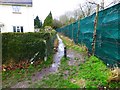
Footpath at the end of Hurst Road
This is shown on the OS map as a Way-Marked trail - "The Avon Valley Path" one can be within 10 feet of this on Hurst Road and not see it!
Image: © David Lally
Taken: 27 Feb 2017
0.25 miles