IMAGES TAKEN NEAR TO
Collins Lane, RINGWOOD, BH24 1LD
Introduction
This page details the photographs taken nearby to Collins Lane, BH24 1LD by members of the Geograph project.
The Geograph project started in 2005 with the aim of publishing, organising and preserving representative images for every square kilometre of Great Britain, Ireland and the Isle of Man.

There are currently over 7.5m images from over14,400 individuals and you can help contribute to the project by visiting https://www.geograph.org.uk
Image Map
Images are licensed for reuse under creativecommons.org/licenses/by-sa/2.0
Notes
- Clicking on the map will re-center to the selected point.
- The higher the marker number, the further away the image location is from the centre of the postcode.
Image Listing (159 Images Found)
Images are licensed for reuse under creativecommons.org/licenses/by-sa/2.0
Image
Details
Distance
1
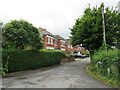
Middle Lane, Ringwood
Middle Lane is a residential road in the town of Ringwood, in Hampshire.
Image: © Malc McDonald
Taken: 20 Aug 2021
0.02 miles
2
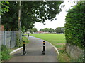
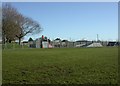
Path across a recreation ground, Ringwood
A path across a recreation ground in the town of Ringwood, in Hampshire.
Image: © Malc McDonald
Taken: 20 Aug 2021
0.05 miles
3
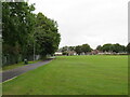
Recreation Ground, Ringwood
A recreation ground in the Hampshire town of Ringwood.
Image: © Malc McDonald
Taken: 20 Aug 2021
0.05 miles
4
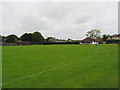
Carvers recreation grounds, Ringwood
This is slightly more built up than it was 30 years ago, with tennis courts and skateboard park.
Image: © Peter Facey
Taken: 28 May 2006
0.05 miles
5
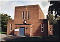
Church of the Sacred Heart & St Theresa of Lisieux, Ringwood
Erected in 1936 for the Roman Catholics.
Image: © Michael FORD
Taken: Unknown
0.11 miles
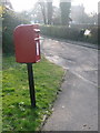
6
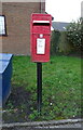
Elizabeth II postbox on School Lane
Postbox No. BH24 25.
Image: © JThomas
Taken: 22 Mar 2022
0.11 miles
7
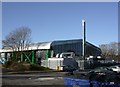
Ringwood Health & Leisure
Off Parsonage Barn Lane. http://www.newforest.gov.uk/index.cfm?articleid=1150
Image: © Mike Faherty
Taken: 9 Jan 2011
0.12 miles
8
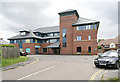
Ringwood Medical Centre, The Close
As I recall, in the 1950s GPs treated patients from rooms in their private homes. In the 1960s some Ringwood GPs clubbed together and built a Health Centre in the road behind the Post Office (then a through road to Mansfield Road, now The Close). A few years later, they built an even better one next door and turned the old one into a drop-in centre for elderly people. Around 2000, this was demolished and the present centre was built.
Image: © Peter Facey
Taken: 23 May 2006
0.12 miles
9
Ringwood: postbox № BH24 25, Mansfield Road
This small postbox stands in a little service road which would originally have been the main carriageway of Mansfield Road before the eased bend and roundabout were installed. It is on the corner of a road suriously named Quomp and is emptied finally at 5:30pm on weekdays and at 12:45pm on Saturdays.
Image: © Chris Downer
Taken: 20 Mar 2011
0.12 miles
10
Ringwood, skate park
In Carvers Recreation Ground, off Southampton Road. http://www.ringwood.gov.uk/Leisure_and_Tourism/Youth/Content/Skate%20Park.html
Image: © Mike Faherty
Taken: 9 Jan 2011
0.12 miles