IMAGES TAKEN NEAR TO
Bickerley Road, RINGWOOD, BH24 1EP
Introduction
This page details the photographs taken nearby to Bickerley Road, BH24 1EP by members of the Geograph project.
The Geograph project started in 2005 with the aim of publishing, organising and preserving representative images for every square kilometre of Great Britain, Ireland and the Isle of Man.

There are currently over 7.5m images from over14,400 individuals and you can help contribute to the project by visiting https://www.geograph.org.uk
Image Map
Images are licensed for reuse under creativecommons.org/licenses/by-sa/2.0
Notes
- Clicking on the map will re-center to the selected point.
- The higher the marker number, the further away the image location is from the centre of the postcode.
Image Listing (515 Images Found)
Images are licensed for reuse under creativecommons.org/licenses/by-sa/2.0
Image
Details
Distance
1
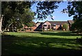
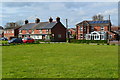
Houses on Bickerley Road, Ringwood
Seen across Bickerley Pocket Park from the east side of Image
Image: © Derek Harper
Taken: 12 Oct 2009
0.02 miles
2
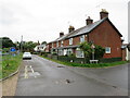
Bickerley Road, Ringwood
Houses on Bickerley Road in Ringwood.
Image: © Malc McDonald
Taken: 20 Aug 2021
0.05 miles
3
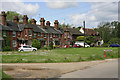
Bickerley Terrace, Ringwood
This terrace forms the northwestern end of The Bickerley. The road visible is Bickerley Road which is a dead end. A plaque on the terrace dates it to 1882.
Image: © Peter Facey
Taken: 23 May 2006
0.05 miles
4
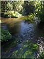
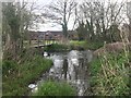
Bickerley Mill Stream
Looking down the mill stream, with weed growing in its clear waters, from Image
Image: © Derek Harper
Taken: 12 Oct 2009
0.05 miles
5
Ford at Ringwood
This field access ford is found at Ringwood.
Image: © John Walton
Taken: 10 Apr 2017
0.05 miles
6
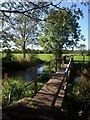
Footbridge over Bickerley Mill Stream
The bridge by which the Avon Valley Path crosses to the mill stream's right bank from Bickerley Pocket Park.
Image: © Derek Harper
Taken: 12 Oct 2009
0.06 miles
8
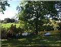
Bickerley Pocket Park
The small area of park is between Bickerley Road and the Bickerley Mill Stream, seen here flowing to the left. On the right, to the north of the water meadows in the Avon valley, can be seen one of park homes at Stubbings Meadow.
Image: © Derek Harper
Taken: 12 Oct 2009
0.07 miles
9
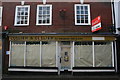
Old Shop Front, Ringwood
This old shop front was revealed recently in the High Street.
Image: © Stuart Buchan
Taken: 7 Nov 2008
0.07 miles
10

Footpath, Ringwood
Ringwood Footpath 57 makes its way between linear plots between Bickerlyey Road and the High Street.
Image: © Derek Harper
Taken: 12 Oct 2009
0.07 miles