IMAGES TAKEN NEAR TO
Derritt Lane, CHRISTCHURCH, BH23 8AT
Introduction
This page details the photographs taken nearby to Derritt Lane, BH23 8AT by members of the Geograph project.
The Geograph project started in 2005 with the aim of publishing, organising and preserving representative images for every square kilometre of Great Britain, Ireland and the Isle of Man.

There are currently over 7.5m images from over14,400 individuals and you can help contribute to the project by visiting https://www.geograph.org.uk
Image Map (Loading...)


Getting Data...Please wait
Leaflet Map data © OpenStreetMap
Images are licensed for reuse under creativecommons.org/licenses/by-sa/2.0
Notes
- Clicking on the map will re-center to the selected point.
- The higher the marker number, the further away the image location is from the centre of the postcode.
Image Listing (25 Images Found)
Images are licensed for reuse under creativecommons.org/licenses/by-sa/2.0
Image
Details
Distance
1
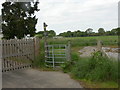
Bransgore, kissing gate.
Gate near the Eastern end of a footpath from Ripley; to the left, one of the entrances to Image
Image: © Mike Faherty
Taken: 10 May 2009
0.06 miles
2
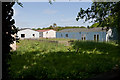
Huts in Merryfield Park
These former RAF camp huts, at the eastern end of the park, seemed to be in use at time of photographing, whereas all those to the west of them were derelict.
Image: © Peter Facey
Taken: 6 Jun 2010
0.08 miles
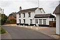
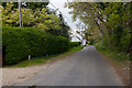
4
The Old Cottage, Chapel Lane
Chapel Lane to right. Camera held above head.
Image: © Peter Facey
Taken: 13 May 2010
0.13 miles
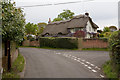
6
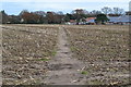
Path across stubble field near Heatherstone Grange
Image: © David Martin
Taken: 30 Nov 2019
0.15 miles
7
Unused huts at Merryfield Park
(elevated camera position)
Image: © Peter Facey
Taken: 6 Jun 2010
0.16 miles
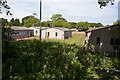
9
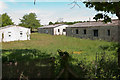
Unused part of Merryfield Park
A former RAF camp now privately owned. These huts are derelict. The huts here were laid out on an H pattern, the lefthand hut forming the cross of the H and the other two the righthand vertical. Two more huts (off-picture left) form the lefthand vertical. (elevated camera position)
Image: © Peter Facey
Taken: 6 Jun 2010
0.19 miles
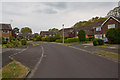
10
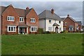
Heatherstone Grange housing development, Bransgore
Completed in 2018, on the site of the former RAF Sopley Camp.
Image: © David Martin
Taken: 30 Nov 2019
0.19 miles