IMAGES TAKEN NEAR TO
Campbell Road, CHRISTCHURCH, BH23 7LY
Introduction
This page details the photographs taken nearby to Campbell Road, BH23 7LY by members of the Geograph project.
The Geograph project started in 2005 with the aim of publishing, organising and preserving representative images for every square kilometre of Great Britain, Ireland and the Isle of Man.

There are currently over 7.5m images from over14,400 individuals and you can help contribute to the project by visiting https://www.geograph.org.uk
Image Map
Images are licensed for reuse under creativecommons.org/licenses/by-sa/2.0
Notes
- Clicking on the map will re-center to the selected point.
- The higher the marker number, the further away the image location is from the centre of the postcode.
Image Listing (23 Images Found)
Images are licensed for reuse under creativecommons.org/licenses/by-sa/2.0
Image
Details
Distance
1
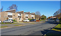
Campbell Road, Burton
This road, also a bus route, cuts through the modern housing developments of north Burton.
The roof line of the houses on the left creates an interesting sawtooth pattern.
Image: © mike smith
Taken: 8 Feb 2011
0.06 miles
2
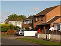
Burton: postbox № BH23 73, Campbell Road
One of five postboxes in Burton.
Image: © Chris Downer
Taken: 23 Jul 2009
0.07 miles
3
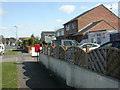
Burton, Campbell Road
Road with modern housing; compare with Image around the corner. Pillar postbox in the foreground is EIIR and bears the number BH23 73.
Image: © Mike Faherty
Taken: 22 Mar 2009
0.08 miles
4
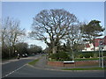
Burton, oak tree
Fine old oak tree in the garden of a house in Stony Lane, just North of Campbell Road.
Image: © Mike Faherty
Taken: 22 Mar 2009
0.09 miles
5

Salisbury Road, Burton, near Christchurch
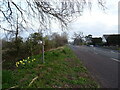
Salisbury Road is on the route of the B3347 as it skirts around the edge of the village of Burton in Dorset. The sign indicates the speed limit changes to 40 miles per hour beyond this point.
Image: © Malc McDonald
Taken: 9 Nov 2025
0.09 miles
7
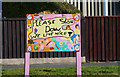
Home-made Traffic Sign
This interesting home-made sign is at the junction of Campbell Road and Park Close in Burton, Dorset.
Image: © mike smith
Taken: 8 Feb 2011
0.12 miles
8

Houses on Stony Lane
Stony Lane runs up the eastern side of the River Avon and these houses face on to the open field of the river's flood plain. It is the B3347 where it runs through the village of Burton.
Image: © Nigel Mykura
Taken: 9 Feb 2019
0.13 miles