IMAGES TAKEN NEAR TO
Salisbury Road, CHRISTCHURCH, BH23 7JQ
Introduction
This page details the photographs taken nearby to Salisbury Road, BH23 7JQ by members of the Geograph project.
The Geograph project started in 2005 with the aim of publishing, organising and preserving representative images for every square kilometre of Great Britain, Ireland and the Isle of Man.

There are currently over 7.5m images from over14,400 individuals and you can help contribute to the project by visiting https://www.geograph.org.uk
Image Map
Images are licensed for reuse under creativecommons.org/licenses/by-sa/2.0
Notes
- Clicking on the map will re-center to the selected point.
- The higher the marker number, the further away the image location is from the centre of the postcode.
Image Listing (32 Images Found)
Images are licensed for reuse under creativecommons.org/licenses/by-sa/2.0
Image
Details
Distance
1
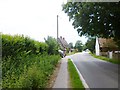
Burton, cottages
Harmony Cottage and Forest Edge, on Salisbury Road.
Image: © Mike Faherty
Taken: 14 Jun 2014
0.01 miles
2
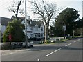
Burton, The Manor Arms
Large Victorian pub between Burton & Somerford. Internally, visible are a small bar to left, drinking area & dining room to right; live music. Cask ale on offer at my visit: Ringwood Best. An estate agent might say that it has potential, but needs some money spending on it. For some customer reviews, http://www.beerintheevening.com/pubs/s/63/6358/Manor_Arms/Burton
Image: © Mike Faherty
Taken: 22 Mar 2009
0.04 miles
3
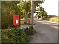
Burton: postbox № BH23 3, Salisbury Road
This small postbox serves the rural southern corner of Burton, and is emptied at 4pm on weekdays and the ultra-early 7:15am on Saturdays.
Beyond, we see the pub sign of the Manor Arms, which has recently closed down.
Image: © Chris Downer
Taken: 23 Jul 2009
0.06 miles


7
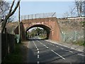
Burton, railway bridge
Bridge carrying the Bournemouth to Southampton railway line over Salisbury Road; the line is on an embankment for about 3km because of the River Avon & floodplain.
Image: © Mike Faherty
Taken: 21 Mar 2009
0.11 miles
8
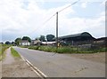
Burton Farm
Dairy farm on Salisbury Road; the farmhouse is in the distance.
Image: © Mike Faherty
Taken: 14 Jun 2014
0.12 miles
9

Salisbury Road, Staple Cross
The two faces of the metal milepost on the left read "Ringwood 8" and "Christchurch 1/2"
Image: © David Martin
Taken: 24 Jan 2022
0.13 miles
10
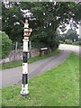
Old Sign Post at Staple Cross
This old sign post, with the traditional-style black and white stripes, is now armless!
Image: © mike smith
Taken: 15 Jul 2007
0.14 miles