IMAGES TAKEN NEAR TO
Crabtree Close, CHRISTCHURCH, BH23 7HG
Introduction
This page details the photographs taken nearby to Crabtree Close, BH23 7HG by members of the Geograph project.
The Geograph project started in 2005 with the aim of publishing, organising and preserving representative images for every square kilometre of Great Britain, Ireland and the Isle of Man.

There are currently over 7.5m images from over14,400 individuals and you can help contribute to the project by visiting https://www.geograph.org.uk
Image Map (22 Images)


Getting Data...Please wait
Leaflet Map data © OpenStreetMap
Images are licensed for reuse under creativecommons.org/licenses/by-sa/2.0
Notes
- Clicking on the map will re-center to the selected point.
- The higher the marker number, the further away the image location is from the centre of the postcode.
Image Listing (22 Images Found)
Images are licensed for reuse under creativecommons.org/licenses/by-sa/2.0
Image
Details
Distance
1
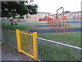
Playground area
View from the Avon Valley footpath.
Image: © Mat Tuck
Taken: 9 Jul 2013
0.08 miles
2
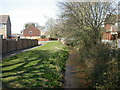
Burton, Clockhouse Stream
A stream that rises near Bransgore and flows into the Avon South of Burton; seen here from a footbridge on the Avon Valley Path near Burnham Road.
Image: © Mike Faherty
Taken: 22 Mar 2009
0.09 miles
3
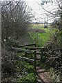
Burton, gate
Fixed gate on Stony Lane, on the section of the Avon Valley Path from Burton to Christchurch http://www3.hants.gov.uk/longdistance/avon-valley-path/sopley-christchurch.htm
Image: © Mike Faherty
Taken: 22 Mar 2009
0.09 miles
4
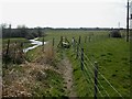
Burton, stile
Stile on the Avon Valley Path http://www3.hants.gov.uk/longdistance/avon-valley-path/sopley-christchurch.htm To the left, Clockhouse Stream, ahead, water meadows.
Image: © Mike Faherty
Taken: 22 Mar 2009
0.10 miles
5
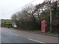
Burton: telephone box on Stoney Lane
A red phone box stands alongside the B3347, originally the main A338 between Ringwood and Christchurch before the Spur Road was put in in the 1960s, parallel but a couple of miles to the west.
Image: © Chris Downer
Taken: 23 Mar 2013
0.11 miles

7
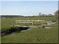
Burton, footbridge
Footbridge across Clockhouse Stream, on the Avon Valley Path http://www3.hants.gov.uk/longdistance/avon-valley-path/sopley-christchurch.htm
Image: © Mike Faherty
Taken: 22 Mar 2009
0.14 miles
8
Foot bridge over stream
Avon Valley footpath passing over the stream adjacent to Stoney Lane.
Image: © Mat Tuck
Taken: 9 Jul 2013
0.14 miles
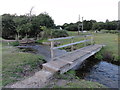
10

Avon Valley Path Footbridge
The whole of this area is very wet flood plain. This bridge crosses a large drainage course on the section of path between the centre of Christchurch and the village of Burton.
Image: © Nigel Mykura
Taken: 9 Feb 2019
0.15 miles