IMAGES TAKEN NEAR TO
Lyndhurst Road, CHRISTCHURCH, BH23 7DN
Introduction
This page details the photographs taken nearby to Lyndhurst Road, BH23 7DN by members of the Geograph project.
The Geograph project started in 2005 with the aim of publishing, organising and preserving representative images for every square kilometre of Great Britain, Ireland and the Isle of Man.

There are currently over 7.5m images from over14,400 individuals and you can help contribute to the project by visiting https://www.geograph.org.uk
Image Map (Loading...)


Getting Data...Please wait
Leaflet Map data © OpenStreetMap
Images are licensed for reuse under creativecommons.org/licenses/by-sa/2.0
Notes
- Clicking on the map will re-center to the selected point.
- The higher the marker number, the further away the image location is from the centre of the postcode.
Image Listing (15 Images Found)
Images are licensed for reuse under creativecommons.org/licenses/by-sa/2.0
Image
Details
Distance
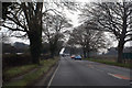
2
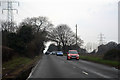
New Forest : Lyndhurst Road A35
Heading into Christchurch on the A35.
Image: © Lewis Clarke
Taken: 25 Mar 2018
0.04 miles
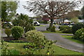
4
Bungalows on The Meadway, Highcliffe
This is at the northern edge of a massive expanse of housing built since the 1960s, stretching south from the A35/railway line to the centre of Highcliffe.
Image: © mike smith
Taken: 14 Mar 2007
0.12 miles
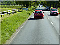
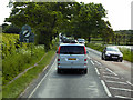
5
New Forest : Lyndhurst Road A35
Heading towards Christchurch on the A35.
Image: © Lewis Clarke
Taken: 25 Mar 2018
0.15 miles
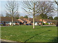
7
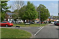
Triangular green beside Clive Road and Havelock Way
Image: © David Martin
Taken: 23 Apr 2022
0.16 miles
9
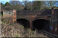
WWII defences in the environs of Bournemouth & Christchurch: Roeshot Hill, Christchurch - pillbox (1)
-
Pillbox (variant): DoB ID: S0000499
This small variant type pillbox was rather cunningly built into the N side of the A35 road bridge over the railway at Roeshot Hill. It was designed specifically for this site, and has just a single embrasure in the front. The alignment is SW along the railway track towards Christchurch.
Image
Image: © Mike Searle
Taken: 3 Mar 2016
0.18 miles
10
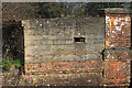
WWII defences in the environs of Bournemouth & Christchurch: Roeshot Hill, Christchurch - pillbox (2)
-
Pillbox (variant): DoB ID: S0000499
A telephoto view of the pillbox built into the road bridge over the railway at Roeshot Hill near Hinton Admiral station.
Image
Image: © Mike Searle
Taken: 3 Mar 2016
0.18 miles