IMAGES TAKEN NEAR TO
Aviation Park West, CHRISTCHURCH, BH23 6EW
Introduction
This page details the photographs taken nearby to Aviation Park West, BH23 6EW by members of the Geograph project.
The Geograph project started in 2005 with the aim of publishing, organising and preserving representative images for every square kilometre of Great Britain, Ireland and the Isle of Man.

There are currently over 7.5m images from over14,400 individuals and you can help contribute to the project by visiting https://www.geograph.org.uk
Image Map
Images are licensed for reuse under creativecommons.org/licenses/by-sa/2.0
Notes
- Clicking on the map will re-center to the selected point.
- The higher the marker number, the further away the image location is from the centre of the postcode.
Image Listing (14 Images Found)
Images are licensed for reuse under creativecommons.org/licenses/by-sa/2.0
Image
Details
Distance
1
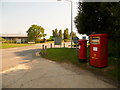
Hurn: postbox №s BH23 68 and BH23 517, Enterprise Way
These two postboxes serve the large Airport West industrial estate, situated as its name suggests around the western periphery of Bournemouth International Airport.
The regular box, for stamped items, is box BH23 68 and is emptied finally at 5pm on weekdays and at noon on Saturdays. Its larger neighbour is for franked mail, and is emptied finally at 6:30pm on weekdays; it is closed on Saturdays.
Image: © Chris Downer
Taken: 9 Aug 2009
0.05 miles
2
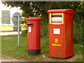
Hurn: two postboxes and a rabbit
A closer look at Image, while the last of four rabbits scarpers to seclusion following my arrival.
Image: © Chris Downer
Taken: 9 Aug 2009
0.06 miles
3
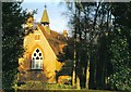
East Parley: former church of St. Barnabas
In a tiny hamlet now dwarfed even more by Bournemouth Airport, this church is now a private dwelling.
Image: © Chris Downer
Taken: Unknown
0.08 miles
4
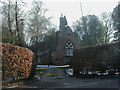
East Parley, former chapel
Marked on old OS maps as Baptist Particular Chapel; now converted for domestic use.
Image: © Mike Faherty
Taken: 7 Feb 2009
0.09 miles
5
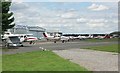
Flight Training Centre
These planes are parked outside of the Bournemouth Commercial Flight Training Centre, at Bournemouth International Airport.
Image: © mike smith
Taken: 29 Jul 2007
0.09 miles
6
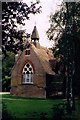
Former St Barnabas, East Parley
Grade 2 listed building erected in 1862. Now converted into a private residence.
Image: © Michael FORD
Taken: Unknown
0.10 miles
7
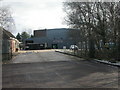
Hurn Material Recycling Facility
Recyclable materials are gathered and stored here before being sent away for re-cycling. For more information, see http://212.104.140.176/index.jsp?articleid=387046
Image: © Mike Faherty
Taken: 7 Feb 2009
0.11 miles
8
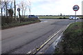
Road Junction at East Parley
The main runway for Bournemouth Airport is in the space behind the two cars which are coming out of the airport.
Image: © Nigel Mykura
Taken: 7 Feb 2019
0.17 miles
9
Bournemouth Airport, Western side
Looking East over to the runway. For a view of the Eastern side, see Image
Image: © Mike Faherty
Taken: 7 Feb 2009
0.17 miles
10
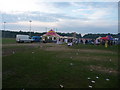
East Parley : Bournemouth University Summer Ball
It's still the beginning of the event which went on until around 3am, and the mess is building up.
Image: © Lewis Clarke
Taken: 5 Jun 2010
0.22 miles