IMAGES TAKEN NEAR TO
Pitt House Lane, CHRISTCHURCH, BH23 6AU
Introduction
This page details the photographs taken nearby to Pitt House Lane, BH23 6AU by members of the Geograph project.
The Geograph project started in 2005 with the aim of publishing, organising and preserving representative images for every square kilometre of Great Britain, Ireland and the Isle of Man.

There are currently over 7.5m images from over14,400 individuals and you can help contribute to the project by visiting https://www.geograph.org.uk
Image Map (Loading...)


Getting Data...Please wait
Leaflet Map data © OpenStreetMap
Images are licensed for reuse under creativecommons.org/licenses/by-sa/2.0
Notes
- Clicking on the map will re-center to the selected point.
- The higher the marker number, the further away the image location is from the centre of the postcode.
Image Listing (13 Images Found)
Images are licensed for reuse under creativecommons.org/licenses/by-sa/2.0
Image
Details
Distance
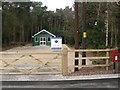
1
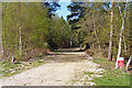
Entrance to Woodland, Hurn
This entrance is off Pithouse Lane. As can be seen from the sign "No Public Access", this is private woodland. The photo was taken over the gate.
Image: © mike smith
Taken: 8 Apr 2011
0.03 miles
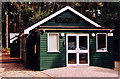
2
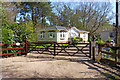
Mobile Home near Hurn
Hidden in woodland along a narrow lane is this attractive mobile home.
Image: © mike smith
Taken: 8 Apr 2011
0.03 miles
3
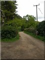
Hurn, Pit(t)house Lane
At the Northern end of Pithouse Lane, leading from Avon Causeway to Pithouse Farm. At the Southern end of the lane are two Christchurch Borough street name signs, one calling the lane Pithouse Lane, and the other, opposite, Pitthouse Lane; take your pick! OS goes for a single T.
Image: © Mike Faherty
Taken: 4 May 2009
0.05 miles
4
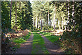
Entrance to Woodland, Hurn
This is one of two entrances to private woodland off Pithouse Lane. A small sign reads "Private". The photo was taken over the gate.
Image: © mike smith
Taken: 8 Apr 2011
0.09 miles
5
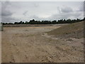
Avon Common, sand extraction
The site of a sandpit that has yet to come onstream; according to Dorset's Minerals & Waste Plan, 2.5 million tonnes of sand & gravel can be extracted here. The earthworks are to shield the site from neighbours and the A338. For the plan, see Avon Common at http://www.dorsetforyou.com/media/pdf/l/s/AnnexAwithimagesInset1to4_1.pdf
Image: © Mike Faherty
Taken: 4 May 2009
0.19 miles
6
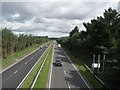
A338 Bournemouth Spur Road
This 4-lane road provides a vital link between Bournemouth and the A31 trunk route.
Image: © mike smith
Taken: 16 Jun 2007
0.24 miles
7

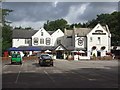
Avon Causeway pub
Originally Hurn station, built 1862 by the Ringwood, Christchurch & Bournemouth Railway Co; closed 1935, and converted to pub & hotel. The pub has its own static diesel shunter & Pulman car; internally, it has several rooms rather blandly refurbished. Cask ales on offer at my visit: Wadworth 6X, Henry's, Bishop's Tipple, Horizon & Malt & Hops. As you might expect, lots of railway memorabilia inside.
http://www.subbrit.org.uk/sb-sites/stations/h/hurn/index.shtml
Image: © Mike Faherty
Taken: 27 Nov 2008
0.24 miles
8
Hurn: the chapel
Hurn Chapel lies somewhat east of the village centre, close to the Avon Causeway Hotel which used to be the railway station. The surroundings have been cleared since June 2007, when the following picture was taken: Image
Image: © Chris Downer
Taken: 2 Mar 2008
0.24 miles
10
Avon Causeway Hotel
This hotel was originally Hurn Railway Station. It opened in 1862 on a branch line between Ringwood and Christchurch - several years before the main line between Southampton and Bournemouth was opened. Once the main line was established few passengers used the branch. It and Hurn station closed in September 1935.
Image: © mike smith
Taken: 16 Jun 2007
0.25 miles