IMAGES TAKEN NEAR TO
Hurn, CHRISTCHURCH, BH23 6AF
Introduction
This page details the photographs taken nearby to BH23 6AF by members of the Geograph project.
The Geograph project started in 2005 with the aim of publishing, organising and preserving representative images for every square kilometre of Great Britain, Ireland and the Isle of Man.

There are currently over 7.5m images from over14,400 individuals and you can help contribute to the project by visiting https://www.geograph.org.uk
Image Map
Images are licensed for reuse under creativecommons.org/licenses/by-sa/2.0
Notes
- Clicking on the map will re-center to the selected point.
- The higher the marker number, the further away the image location is from the centre of the postcode.
Image Listing (38 Images Found)
Images are licensed for reuse under creativecommons.org/licenses/by-sa/2.0
Image
Details
Distance
1
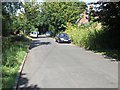
Blackwater Hamlet
This was the main Hurn Road, before the A338 Bournemouth Spur Road was built. Hurn Road now goes over the A338, just to the left of this picture. This hamlet of Blackwater was cut in half, there being more houses on the other side of the A338. There are four homes on this side.
Image: © mike smith
Taken: 25 Aug 2007
0.02 miles

3
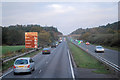
The A338
Heading north out of Bournemouth on a stormy day.
Image: © william
Taken: 14 Nov 2009
0.08 miles
4
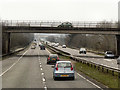
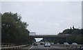
Bridge (Hurn Road) over the Southbound A338
Image: © David Dixon
Taken: 1 Apr 2013
0.08 miles
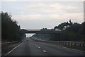
7
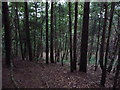
Christchurch: western slope of Blackwater Hill
Looking from the top of Blackwater Hill down the thickly wooded western slope. It is a peaceful setting, but peaceful is not really the word, since the main A338 runs close by. It is not properly visible but there is a constant raw of traffic – and quick flashes of colour can be seen roughly centre of the picture, with each vehicle that passes by.
Image: © Chris Downer
Taken: 31 Jul 2009
0.14 miles
8
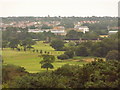
Christchurch: immediate view south from Blackwater Hill
Looking south across the treetops on the slopes of Blackwater Hill, we see the Iford golf driving range and, beyond, the long grey roof of the Tesco superstore.
Image: © Chris Downer
Taken: 31 Jul 2009
0.14 miles
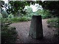
9
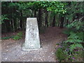
Christchurch: trig point on Blackwater Hill
Standing at 49m above sea level, this is one of a seemingly disproportionately large number of trig points in the Christchurch area.
Image: © Chris Downer
Taken: 31 Jul 2009
0.14 miles
10
Christchurch: Blackwater trig point from in the trees
Looking out from the trees on the Image, giving us a different view of the Image and showing us that a chunk is missing from the left corner.
Image: © Chris Downer
Taken: 31 Jul 2009
0.14 miles