IMAGES TAKEN NEAR TO
Holly Lane, CHRISTCHURCH, BH23 5QQ
Introduction
This page details the photographs taken nearby to Holly Lane, BH23 5QQ by members of the Geograph project.
The Geograph project started in 2005 with the aim of publishing, organising and preserving representative images for every square kilometre of Great Britain, Ireland and the Isle of Man.

There are currently over 7.5m images from over14,400 individuals and you can help contribute to the project by visiting https://www.geograph.org.uk
Image Map
Images are licensed for reuse under creativecommons.org/licenses/by-sa/2.0
Notes
- Clicking on the map will re-center to the selected point.
- The higher the marker number, the further away the image location is from the centre of the postcode.
Image Listing (25 Images Found)
Images are licensed for reuse under creativecommons.org/licenses/by-sa/2.0
Image
Details
Distance
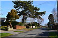
1
Walkford, allotments
Walkford Road Allotment Site, between Walkford Road and Hurst Close.
Image: © Mike Faherty
Taken: 20 Sep 2010
0.14 miles
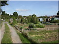
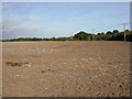
2
Farm track across fields north of Walkford
Image: © David Martin
Taken: 13 May 2019
0.17 miles
3
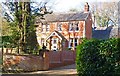
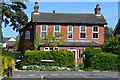
Late Victorian House
This is near to Walkford on Walkford Lane.
Image: © mike smith
Taken: 8 Mar 2012
0.18 miles
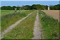
4
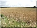
Barley Field
North of the railway line, the area remains very rural, and is in Hampshire. South of the railway, the dense Highcliffe/Walkford conurbation is part of Dorset.
Image: © mike smith
Taken: 17 Jul 2007
0.19 miles
5
Walkford, stubble field
Fields in the area are large, flat and featureless. The crop appears to have been maize.
Image: © Mike Faherty
Taken: 20 Sep 2010
0.20 miles
6
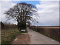
Entrance to the Woodland Burial Ground
Driveway to the Hinton Park burial ground http://www.woodlandburialground.co.uk/Our-Burial-Grounds/Hinton-Park/.
Image: © Ian Paterson
Taken: 13 Mar 2013
0.20 miles
7
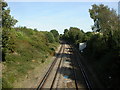
Walkford, railway lines
On the Waterloo to Weymouth mainline; the next station is New Milton. Seen from Wyndham Road.
Image: © Mike Faherty
Taken: 20 Sep 2010
0.20 miles
9
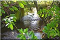
Walkford Brook
This stream has three main sources in the southern New Forest. For some of its distance it forms the boundary between Hampshire and Dorset, flowing through Chewton Bunny, before entering the sea at Highcliffe.
Image: © mike smith
Taken: 8 Mar 2012
0.21 miles