IMAGES TAKEN NEAR TO
Loraine Avenue, CHRISTCHURCH, BH23 5LB
Introduction
This page details the photographs taken nearby to Loraine Avenue, BH23 5LB by members of the Geograph project.
The Geograph project started in 2005 with the aim of publishing, organising and preserving representative images for every square kilometre of Great Britain, Ireland and the Isle of Man.

There are currently over 7.5m images from over14,400 individuals and you can help contribute to the project by visiting https://www.geograph.org.uk
Image Map
Images are licensed for reuse under creativecommons.org/licenses/by-sa/2.0
Notes
- Clicking on the map will re-center to the selected point.
- The higher the marker number, the further away the image location is from the centre of the postcode.
Image Listing (36 Images Found)
Images are licensed for reuse under creativecommons.org/licenses/by-sa/2.0
Image
Details
Distance
1
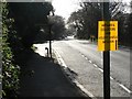
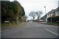
Highcliffe: Lymington Road
Looking along Lymington Road towards Highcliffe village centre. As its name suggests, it is the road to Lymington – the A337. The bus stop is by the junction of Mill Road.
Image: © Chris Downer
Taken: 1 Mar 2008
0.07 miles
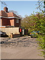
2
Chewton Lodge
The view from Mill Lane in Highcliffe, Dorset.
Image: © Gordon Griffiths
Taken: 3 Jun 2023
0.08 miles
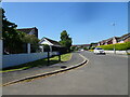
3
Mill Lane Junction
The view of Montagu Road in Highcliffe, Dorset.
Image: © Gordon Griffiths
Taken: 3 Jun 2023
0.08 miles
5
Highcliffe-on-Sea : Mill Lane
Looking along Mill Lane off of Lymington Road.
Image: © Lewis Clarke
Taken: 26 Mar 2018
0.08 miles
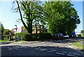
6
Highcliffe: postbox № BH23 18, Mill Lane
This small postbox is emptied at 5:15pm on weekdays and at noon on Saturdays.
Image: © Chris Downer
Taken: 13 Apr 2009
0.08 miles
7
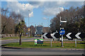
Highcliffe-on-Sea : Lymington Road A337
A roundabout on the A337.
Image: © Lewis Clarke
Taken: 26 Mar 2018
0.09 miles
8
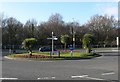
Highcliffe: Mil(e)stone Roundabout
This is Dorset's easternmost roundabout, and is named after a milestone which still stands a few yards away (see Image). The sign facing us has a spelling mistake and says "Milstone Roundabout".
Image: © Chris Downer
Taken: 1 Mar 2008
0.09 miles
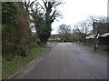
9
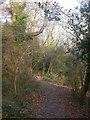
Chewton Bunny, footpath
For the length of Walkford Brook from the A337 to the sea a footpath roughly follows the brook, through a wooded valley of oak, beech and holly.
Image: © Mike Faherty
Taken: 30 Dec 2008
0.09 miles
10
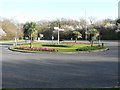
Highcliffe: Milestone Roundabout
Dorset's easternmost roundabout is named after the milestone which is just visible beyond the left-hand road sign. See Image The signpost in the centre of the roundabout predates the boundary change between Hampshire and Dorset in 1974, as the finial says Hampshire.
Image: © Chris Downer
Taken: 1 Mar 2008
0.09 miles