IMAGES TAKEN NEAR TO
Haslemere Avenue, CHRISTCHURCH, BH23 5BQ
Introduction
This page details the photographs taken nearby to Haslemere Avenue, BH23 5BQ by members of the Geograph project.
The Geograph project started in 2005 with the aim of publishing, organising and preserving representative images for every square kilometre of Great Britain, Ireland and the Isle of Man.

There are currently over 7.5m images from over14,400 individuals and you can help contribute to the project by visiting https://www.geograph.org.uk
Image Map
Images are licensed for reuse under creativecommons.org/licenses/by-sa/2.0
Notes
- Clicking on the map will re-center to the selected point.
- The higher the marker number, the further away the image location is from the centre of the postcode.
Image Listing (14 Images Found)
Images are licensed for reuse under creativecommons.org/licenses/by-sa/2.0
Image
Details
Distance
1
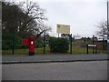
Highcliffe: postbox № BH23 76, Greenways
This Elizabeth II-reign postbox stands at the northern end of Greenways, opposite Denham Drive. It is emptied finally at 5:30pm on weekdays and at 12:15pm on Saturdays.
Behind, we see the grounds of Highcliffe St. Mark Primary, a fairly recent amalgamation of the former St. Mark's Infant and Highcliffe Junior Schools, on the original site of the latter.
Image: © Chris Downer
Taken: 31 Jan 2009
0.09 miles
2
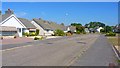
Felton Crescent, Highcliffe, Dorset
This road, as with many others in the area, is lined exclusively with bungalows.
Image: © mike smith
Taken: 4 Sep 2013
0.14 miles
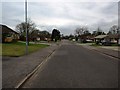
4
Junction Earlesdon Way/Felton Cres, Highcliffe, Dorset
The homes in this area of north Highcliffe are almost exclusively bungalows.
Image: © mike smith
Taken: 4 Sep 2013
0.18 miles
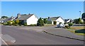
5
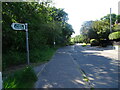
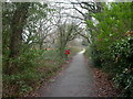
Footpath View
The view along Chewton Common Road from the Gordon Road footpath in Highcliffe.
Image: © Gordon Griffiths
Taken: 31 May 2023
0.20 miles
6
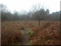
Chewton Common
Chewton Common comprises four parcels of land, separated by housing and roads.
This view is in the largest section, to the north of Chewton Common Road. Bracken, light deciduous tree cover; as seen on a wet January day.
Image: © Mike Faherty
Taken: 16 Jan 2009
0.20 miles
7
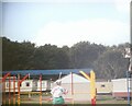
The swings and caravans in the now gone Cobb's Holiday park
Date is approximate.
Image: © Jamie Cormack
Taken: 12 Sep 1994
0.21 miles
8
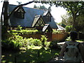
Tiny House end of Chewton Common Footpath
Perhaps this was once just a garage or coach house to the Victorian House next door. Now it is a smart but very tiny house.
Image: © elaine owen
Taken: 25 Aug 2007
0.21 miles
9
Chewton Common Road Path
The view from near Gordon Road in Highcliffe.
Image: © Gordon Griffiths
Taken: 31 May 2023
0.21 miles
10
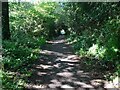
Chewton Common, footpath
The northwestern section of Chewton Common Image has a hard-surfaced footpath running from north to south, with smaller paths radiating from it. Popular with dog-walkers.
Image: © Mike Faherty
Taken: 16 Jan 2009
0.22 miles