IMAGES TAKEN NEAR TO
Greenways, CHRISTCHURCH, BH23 5BB
Introduction
This page details the photographs taken nearby to Greenways, BH23 5BB by members of the Geograph project.
The Geograph project started in 2005 with the aim of publishing, organising and preserving representative images for every square kilometre of Great Britain, Ireland and the Isle of Man.

There are currently over 7.5m images from over14,400 individuals and you can help contribute to the project by visiting https://www.geograph.org.uk
Image Map
Images are licensed for reuse under creativecommons.org/licenses/by-sa/2.0
Notes
- Clicking on the map will re-center to the selected point.
- The higher the marker number, the further away the image location is from the centre of the postcode.
Image Listing (41 Images Found)
Images are licensed for reuse under creativecommons.org/licenses/by-sa/2.0
Image
Details
Distance
1
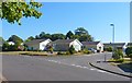
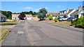
Junction of Earlsdon Way and Crispin Close
This is very much bungalow land in the residential areas of north Highcliffe.
Image: © mike smith
Taken: 4 Sep 2013
0.06 miles
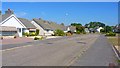
2
Junction Earlesdon Way/Felton Cres, Highcliffe, Dorset
The homes in this area of north Highcliffe are almost exclusively bungalows.
Image: © mike smith
Taken: 4 Sep 2013
0.10 miles
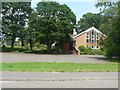
3
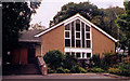
Holy Redeemer Roman Catholic Church, Highcliffe
Erected in 1969.
Image: © Michael FORD
Taken: Unknown
0.10 miles
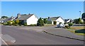
4
Felton Crescent, Highcliffe, Dorset
This road, as with many others in the area, is lined exclusively with bungalows.
Image: © mike smith
Taken: 4 Sep 2013
0.11 miles
5
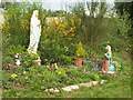
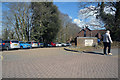
Shrine at the Holy Redeemer Catholic Church
Image: © mike smith
Taken: 15 Apr 2007
0.11 miles
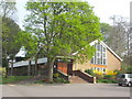
6
Highcliffe: Holy Redeemer Catholic church
Situated in Kilmington Way, among the back residential streets of Highcliffe. The shrine can be seen in the grounds, to the left of the church.
Image: © Chris Downer
Taken: 31 May 2008
0.11 miles
7
Holy Redeemer Catholic Church
This Roman Catholic Church, on Kilmington Way, Highcliffe, was built in 1969. It was constructed on land donated by the sisters of the Marydale Convent (now demolished).
Image: © mike smith
Taken: 15 Apr 2007
0.11 miles
8
Earlesdon Way, Highcliffe, Dorset
There are several blocks of flats in this immediate area.
Image: © mike smith
Taken: 4 Sep 2013
0.13 miles
9
Kilmington Way, Highcliffe
A residential road of bungalows with Georgian-style town houses, visible at the end.
Image: © mike smith
Taken: 4 Sep 2013
0.15 miles
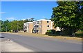
10
Highcliffe-on-Sea : Medical Centre and Clinic
A health centre on Lymington Road.
Image: © Lewis Clarke
Taken: 26 Mar 2018
0.19 miles